You are here: Home > Network List > WY - Yellowstone Wyoming Seismic Network Stations List
> Station YUF Upper Falls, WY, USA > Earthquake Result Viewer
YUF Upper Falls, WY, USA - Earthquake Result Viewer

| Earthquake location: |
Southeast Of Honshu, Japan |
| Earthquake latitude/longitude: |
29.9/140.0 |
| Earthquake time(UTC): |
2023/10/03 (276) 11:38:04 GMT |
| Earthquake Depth: |
12 km |
| Earthquake Magnitude: |
6.1 Mww |
| Earthquake Catalog/Contributor: |
NEIC PDE/us |
|
| Network: |
WY Yellowstone Wyoming Seismic Network |
| Station: |
YUF Upper Falls, WY, USA |
| Lat/Lon: |
44.71 N/110.51 W |
| Elevation: |
2394 m |
|
| Distance: |
81.9 deg |
| Az: |
42.749 deg |
| Baz: |
304.246 deg |
| Ray Param: |
0.047262877 |
| Estimated Moho Depth: |
59.25 km |
| Estimated Crust Vp/Vs: |
1.81 |
| Assumed Crust Vp: |
6.35 km/s |
| Estimated Crust Vs: |
3.518 km/s |
| Estimated Crust Poisson's Ratio: |
0.28 |
|
| Radial Match: |
81.48829 % |
| Radial Bump: |
400 |
| Transverse Match: |
69.15188 % |
| Transverse Bump: |
400 |
| SOD ConfigId: |
31937991 |
| Insert Time: |
2023-10-17 12:03:59.560 +0000 |
| GWidth: |
2.5 |
| Max Bumps: |
400 |
| Tol: |
0.001 |
|
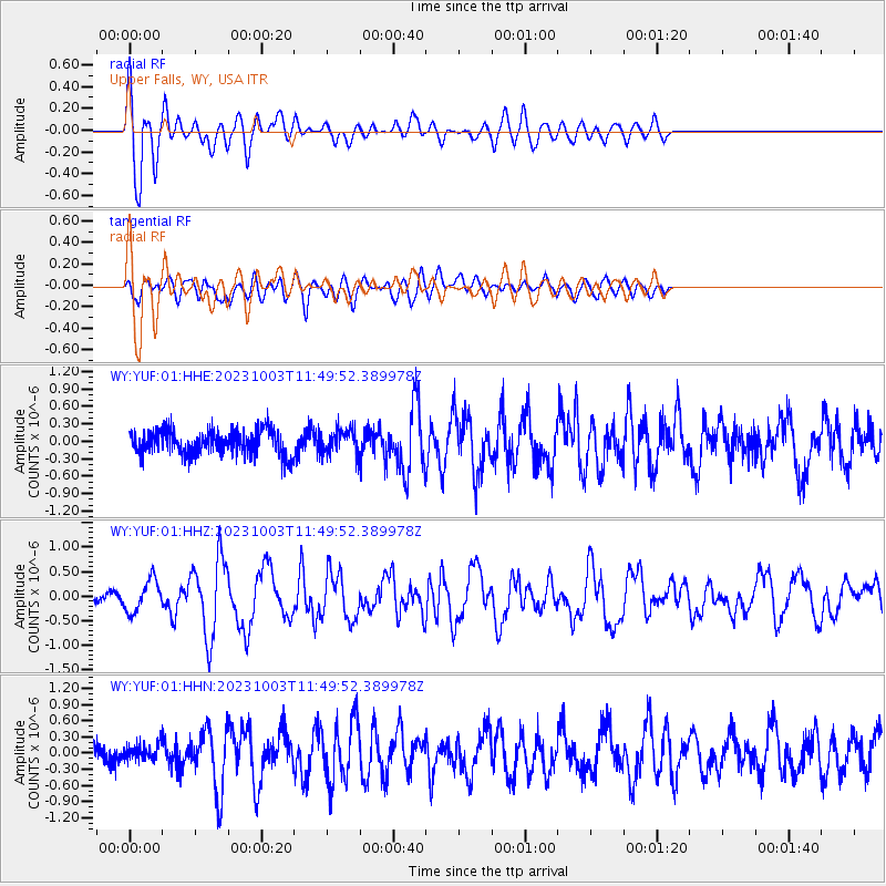
Signal To Noise
| Channel | StoN | STA | LTA |
| WY:YUF:01:HHZ:20231003T11:49:52.389978Z | 3.0559218 | 3.2384173E-7 | 1.0597187E-7 |
| WY:YUF:01:HHN:20231003T11:49:52.389978Z | 0.86516315 | 1.4705589E-7 | 1.6997475E-7 |
| WY:YUF:01:HHE:20231003T11:49:52.389978Z | 1.0412979 | 2.2103526E-7 | 2.1226899E-7 |
| Arrivals |
| Ps | 7.7 SECOND |
| PpPs | 26 SECOND |
| PsPs/PpSs | 33 SECOND |


