You are here: Home > Network List > AK - Alaska Regional Network Stations List
> Station E22K Anaktuvuk Pass, AK, USA > Earthquake Result Viewer
E22K Anaktuvuk Pass, AK, USA - Earthquake Result Viewer
| Earthquake location: |
Southeast Of Honshu, Japan |
| Earthquake latitude/longitude: |
29.9/140.1 |
| Earthquake time(UTC): |
2023/10/03 (276) 15:22:36 GMT |
| Earthquake Depth: |
10 km |
| Earthquake Magnitude: |
5.8 Mww |
| Earthquake Catalog/Contributor: |
NEIC PDE/us |
|
| Network: |
AK Alaska Regional Network |
| Station: |
E22K Anaktuvuk Pass, AK, USA |
| Lat/Lon: |
68.13 N/151.81 W |
| Elevation: |
772 m |
|
| Distance: |
54.5 deg |
| Az: |
25.289 deg |
| Baz: |
261.948 deg |
| Ray Param: |
0.06543804 |
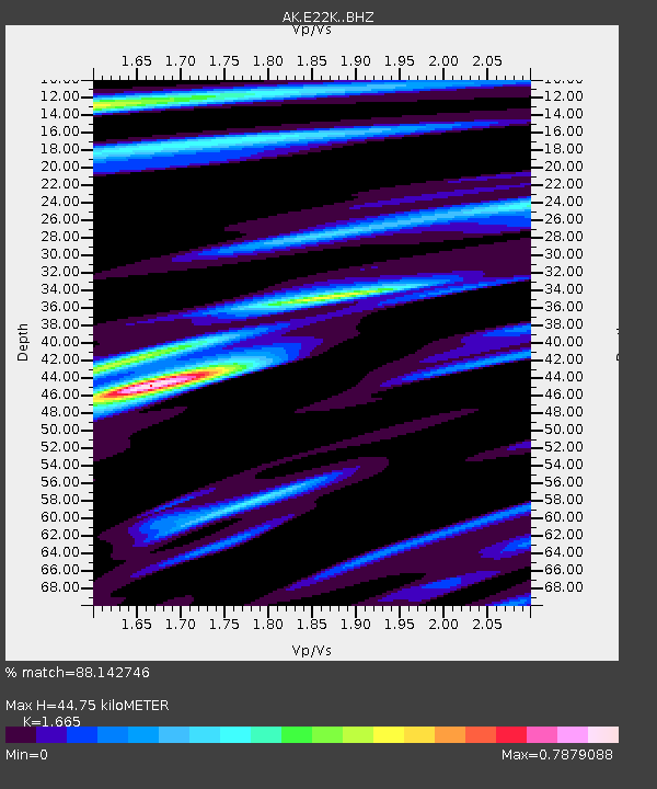
| Estimated Moho Depth: |
44.75 km |
| Estimated Crust Vp/Vs: |
1.66 |
| Assumed Crust Vp: |
6.221 km/s |
| Estimated Crust Vs: |
3.736 km/s |
| Estimated Crust Poisson's Ratio: |
0.22 |
|
| Radial Match: |
88.142746 % |
| Radial Bump: |
301 |
| Transverse Match: |
84.01631 % |
| Transverse Bump: |
400 |
| SOD ConfigId: |
31937991 |
| Insert Time: |
2023-10-17 15:25:25.932 +0000 |
| GWidth: |
2.5 |
| Max Bumps: |
400 |
| Tol: |
0.001 |
|

Signal To Noise
| Channel | StoN | STA | LTA |
| AK:E22K: :BHZ:20231003T15:31:33.360006Z | 4.411507 | 5.5586895E-7 | 1.2600432E-7 |
| AK:E22K: :BHN:20231003T15:31:33.360006Z | 1.0294905 | 8.219421E-8 | 7.98397E-8 |
| AK:E22K: :BHE:20231003T15:31:33.360006Z | 1.9352385 | 2.062504E-7 | 1.0657622E-7 |
| Arrivals |
| Ps | 5.0 SECOND |
| PpPs | 18 SECOND |
| PsPs/PpSs | 23 SECOND |


