You are here: Home > Network List > AK - Alaska Regional Network Stations List
> Station F21K Alatna River, AK, USA > Earthquake Result Viewer
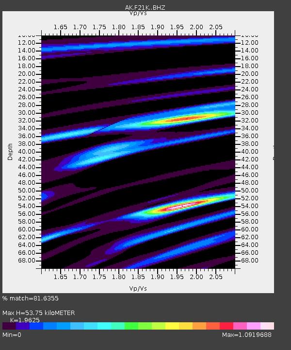
F21K Alatna River, AK, USA - Earthquake Result Viewer
| Earthquake location: |
Southeast Of Honshu, Japan |
| Earthquake latitude/longitude: |
29.9/140.1 |
| Earthquake time(UTC): |
2023/10/03 (276) 15:22:36 GMT |
| Earthquake Depth: |
10 km |
| Earthquake Magnitude: |
5.8 Mww |
| Earthquake Catalog/Contributor: |
NEIC PDE/us |
|
| Network: |
AK Alaska Regional Network |
| Station: |
F21K Alatna River, AK, USA |
| Lat/Lon: |
67.22 N/153.48 W |
| Elevation: |
597 m |
|
| Distance: |
53.7 deg |
| Az: |
26.291 deg |
| Baz: |
260.993 deg |
| Ray Param: |
0.06593215 |
| Estimated Moho Depth: |
53.75 km |
| Estimated Crust Vp/Vs: |
1.96 |
| Assumed Crust Vp: |
6.455 km/s |
| Estimated Crust Vs: |
3.289 km/s |
| Estimated Crust Poisson's Ratio: |
0.32 |
|
| Radial Match: |
81.6355 % |
| Radial Bump: |
371 |
| Transverse Match: |
74.431 % |
| Transverse Bump: |
400 |
| SOD ConfigId: |
31937991 |
| Insert Time: |
2023-10-17 15:25:35.959 +0000 |
| GWidth: |
2.5 |
| Max Bumps: |
400 |
| Tol: |
0.001 |
|

Signal To Noise
| Channel | StoN | STA | LTA |
| AK:F21K: :BHZ:20231003T15:31:27.779989Z | 4.329419 | 4.742797E-7 | 1.0954812E-7 |
| AK:F21K: :BHN:20231003T15:31:27.779989Z | 1.0268462 | 9.1916036E-8 | 8.951296E-8 |
| AK:F21K: :BHE:20231003T15:31:27.779989Z | 2.2303033 | 1.7163168E-7 | 7.6954414E-8 |
| Arrivals |
| Ps | 8.4 SECOND |
| PpPs | 23 SECOND |
| PsPs/PpSs | 32 SECOND |


