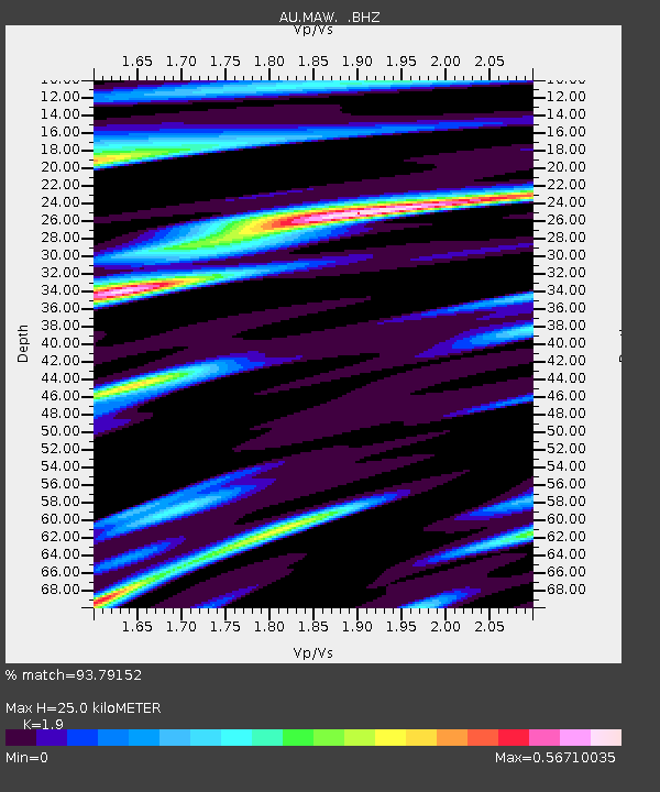
MAW Mawson, Antarctica - Earthquake Result Viewer

Earthquake location: New Britain Region, P.N.G.
Earthquake latitude/longitude: -5.9/150.7
Earthquake time(UTC): 2010/07/20 (201) 19:18:21 GMT
Earthquake Depth: 35 km
Earthquake Magnitude: 5.6 MB, 6.3 MS, 6.3 MW, 6.3 MW
Earthquake Catalog/Contributor: WHDF/NEIC
Network: AU Australian Seismological Centre
Station: MAW Mawson, Antarctica
Lat/Lon: 67.60 S/62.87 E
Elevation: 12 m
Distance: 83.7 deg
Az: 202.657 deg
Baz: 90.256 deg
Ray Param: 0.045921925
Estimated Moho Depth: 25.0 km
Estimated Crust Vp/Vs: 1.90
Assumed Crust Vp: 6.508 km/s
Estimated Crust Vs: 3.425 km/s
Estimated Crust Poisson's Ratio: 0.31
Radial Match: 93.79152 %
Radial Bump: 400
Transverse Match: 78.40564 %
Transverse Bump: 400
SOD ConfigId: 319893
Insert Time: 2011-01-05 08:50:33.017 +0000
GWidth: 2.5
Max Bumps: 400
Tol: 0.001

Signal To Noise

ChannelStoNSTALTA
AU:MAW: :BHZ:20100720T19:30:16.262988Z6.0728481.1789913E-71.9414141E-8
AU:MAW: :BHN:20100720T19:30:16.262988Z1.13484611.9700767E-81.7359858E-8
AU:MAW: :BHE:20100720T19:30:16.262988Z3.13277083.7846892E-81.2080964E-8
Arrivals
Ps3.5 SECOND
PpPs11 SECOND
PsPs/PpSs14 SECOND