You are here: Home > Network List > IW - Intermountain West Stations List
> Station MOOW Moose Ponds, Wyoming, USA > Earthquake Result Viewer
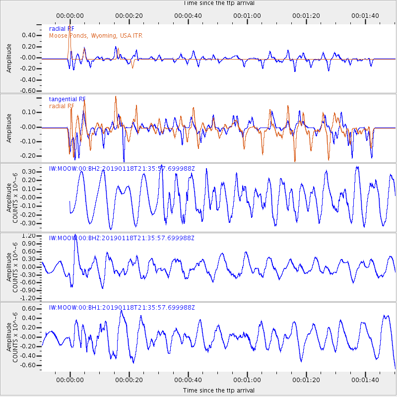
MOOW Moose Ponds, Wyoming, USA - Earthquake Result Viewer
*The percent match for this event was below the threshold and hence no stack was calculated.
| Earthquake location: |
Northern Peru |
| Earthquake latitude/longitude: |
-3.3/-76.9 |
| Earthquake time(UTC): |
2019/01/18 (018) 21:27:01 GMT |
| Earthquake Depth: |
103 km |
| Earthquake Magnitude: |
5.7 Mww |
| Earthquake Catalog/Contributor: |
NEIC PDE/us |
|
| Network: |
IW Intermountain West |
| Station: |
MOOW Moose Ponds, Wyoming, USA |
| Lat/Lon: |
43.75 N/110.74 W |
| Elevation: |
2128 m |
|
| Distance: |
55.9 deg |
| Az: |
330.776 deg |
| Baz: |
137.732 deg |
| Ray Param: |
$rayparam |
*The percent match for this event was below the threshold and hence was not used in the summary stack. |
|
| Radial Match: |
65.14019 % |
| Radial Bump: |
400 |
| Transverse Match: |
56.509785 % |
| Transverse Bump: |
314 |
| SOD ConfigId: |
3260311 |
| Insert Time: |
2019-02-01 21:44:03.155 +0000 |
| GWidth: |
2.5 |
| Max Bumps: |
400 |
| Tol: |
0.001 |
|
Signal To Noise
| Channel | StoN | STA | LTA |
| IW:MOOW:00:BHZ:20190118T21:35:57.699988Z | 3.1951756 | 5.9822634E-7 | 1.8722801E-7 |
| IW:MOOW:00:BH1:20190118T21:35:57.699988Z | 0.83237183 | 1.9262208E-7 | 2.314135E-7 |
| IW:MOOW:00:BH2:20190118T21:35:57.699988Z | 1.0321195 | 2.0171711E-7 | 1.9543968E-7 |
| Arrivals |
| Ps | |
| PpPs | |
| PsPs/PpSs | |


