You are here: Home > Network List > TM - Thai Seismic Monitoring Network Stations List
> Station CHBT Khereethan Dam, Chanthaburi > Earthquake Result Viewer
CHBT Khereethan Dam, Chanthaburi - Earthquake Result Viewer
| Earthquake location: |
Southeast Of Honshu, Japan |
| Earthquake latitude/longitude: |
29.9/140.1 |
| Earthquake time(UTC): |
2023/10/03 (276) 15:22:36 GMT |
| Earthquake Depth: |
10 km |
| Earthquake Magnitude: |
5.8 Mww |
| Earthquake Catalog/Contributor: |
NEIC PDE/us |
|
| Network: |
TM Thai Seismic Monitoring Network |
| Station: |
CHBT Khereethan Dam, Chanthaburi |
| Lat/Lon: |
12.74 N/102.35 E |
| Elevation: |
198 m |
|
| Distance: |
38.8 deg |
| Az: |
252.103 deg |
| Baz: |
57.868 deg |
| Ray Param: |
0.07536321 |
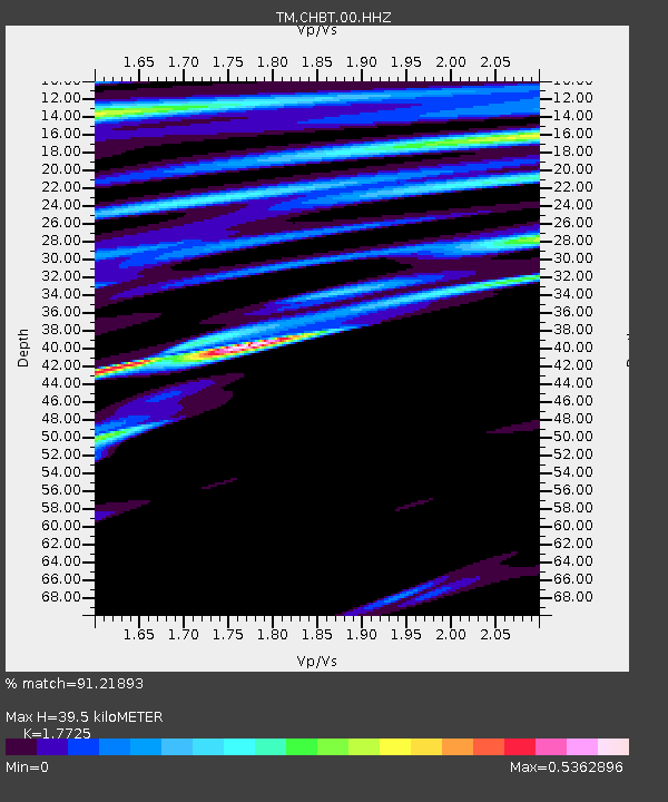
| Estimated Moho Depth: |
39.5 km |
| Estimated Crust Vp/Vs: |
1.77 |
| Assumed Crust Vp: |
6.498 km/s |
| Estimated Crust Vs: |
3.666 km/s |
| Estimated Crust Poisson's Ratio: |
0.27 |
|
| Radial Match: |
91.21893 % |
| Radial Bump: |
400 |
| Transverse Match: |
62.66132 % |
| Transverse Bump: |
400 |
| SOD ConfigId: |
31937991 |
| Insert Time: |
2023-10-17 15:46:40.500 +0000 |
| GWidth: |
2.5 |
| Max Bumps: |
400 |
| Tol: |
0.001 |
|

Signal To Noise
| Channel | StoN | STA | LTA |
| TM:CHBT:00:HHZ:20231003T15:29:31.029989Z | 3.0129356 | 2.5241346E-7 | 8.3776584E-8 |
| TM:CHBT:00:HHN:20231003T15:29:31.029989Z | 1.1035091 | 1.4757401E-7 | 1.3373159E-7 |
| TM:CHBT:00:HHE:20231003T15:29:31.029989Z | 1.610606 | 1.6898122E-7 | 1.0491779E-7 |
| Arrivals |
| Ps | 5.1 SECOND |
| PpPs | 16 SECOND |
| PsPs/PpSs | 21 SECOND |


