KNTN Kanton, Kiritibati - Earthquake Result Viewer
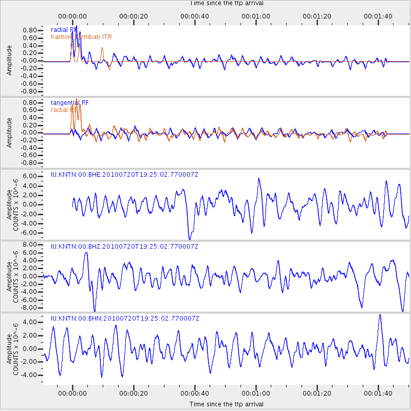
Earthquake location: New Britain Region, P.N.G.
Earthquake latitude/longitude: -5.9/150.7
Earthquake time(UTC): 2010/07/20 (201) 19:18:21 GMT
Earthquake Depth: 35 km
Earthquake Magnitude: 5.6 MB, 6.3 MS, 6.3 MW, 6.3 MW
Earthquake Catalog/Contributor: WHDF/NEIC
Network: IU Global Seismograph Network (GSN - IRIS/USGS)
Station: KNTN Kanton, Kiritibati
Lat/Lon: 2.77 S/171.72 W
Elevation: 20 m
Distance: 37.6 deg
Az: 86.881 deg
Baz: 263.947 deg
Ray Param: 0.0759804
Estimated Moho Depth: 16.5 km
Estimated Crust Vp/Vs: 1.63
Assumed Crust Vp: 4.24 km/s
Estimated Crust Vs: 2.605 km/s
Estimated Crust Poisson's Ratio: 0.20
Radial Match: 80.13274 %
Radial Bump: 306
Transverse Match: 55.902077 %
Transverse Bump: 400
SOD ConfigId: 319893
Insert Time: 2011-01-05 08:54:34.573 +0000
GWidth: 2.5
Max Bumps: 400
Tol: 0.001

Signal To Noise

ChannelStoNSTALTA
IU:KNTN:00:BHZ:20100720T19:25:02.770007Z3.52679942.854091E-68.092581E-7
IU:KNTN:00:BHN:20100720T19:25:02.770007Z0.865440131.1968825E-61.3829756E-6
IU:KNTN:00:BHE:20100720T19:25:02.770007Z1.07697531.37447E-61.2762317E-6
Arrivals
Ps2.5 SECOND
PpPs9.9 SECOND
PsPs/PpSs12 SECOND