You are here: Home > Network List > TA - USArray Transportable Network (new EarthScope stations) Stations List
> Station G05D Wamic, OR, USA > Earthquake Result Viewer
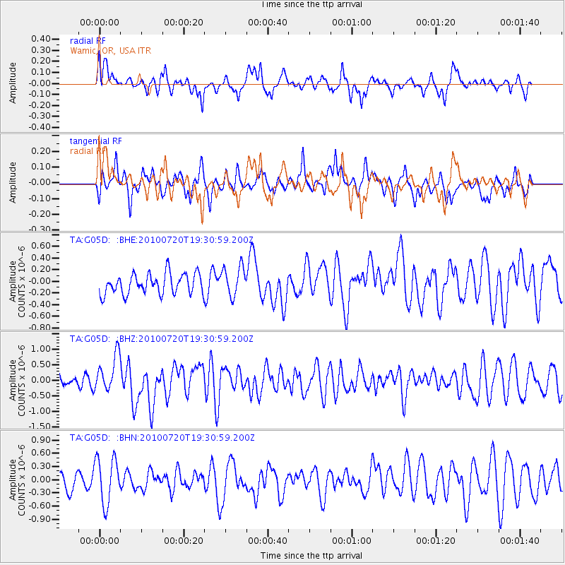
G05D Wamic, OR, USA - Earthquake Result Viewer
*The percent match for this event was below the threshold and hence no stack was calculated.
| Earthquake location: |
New Britain Region, P.N.G. |
| Earthquake latitude/longitude: |
-5.9/150.7 |
| Earthquake time(UTC): |
2010/07/20 (201) 19:18:21 GMT |
| Earthquake Depth: |
35 km |
| Earthquake Magnitude: |
5.6 MB, 6.3 MS, 6.3 MW, 6.3 MW |
| Earthquake Catalog/Contributor: |
WHDF/NEIC |
|
| Network: |
TA USArray Transportable Network (new EarthScope stations) |
| Station: |
G05D Wamic, OR, USA |
| Lat/Lon: |
45.24 N/121.32 W |
| Elevation: |
592 m |
|
| Distance: |
92.7 deg |
| Az: |
44.98 deg |
| Baz: |
264.421 deg |
| Ray Param: |
$rayparam |
*The percent match for this event was below the threshold and hence was not used in the summary stack. |
|
| Radial Match: |
71.18679 % |
| Radial Bump: |
400 |
| Transverse Match: |
44.153988 % |
| Transverse Bump: |
400 |
| SOD ConfigId: |
319893 |
| Insert Time: |
2011-01-05 08:56:49.067 +0000 |
| GWidth: |
2.5 |
| Max Bumps: |
400 |
| Tol: |
0.001 |
|
Signal To Noise
| Channel | StoN | STA | LTA |
| TA:G05D: :BHZ:20100720T19:30:59.200Z | 2.3608537 | 5.9737715E-7 | 2.5303436E-7 |
| TA:G05D: :BHN:20100720T19:30:59.200Z | 1.7976472 | 5.244639E-7 | 2.9175018E-7 |
| TA:G05D: :BHE:20100720T19:30:59.200Z | 1.4800298 | 2.5720277E-7 | 1.7378214E-7 |
| Arrivals |
| Ps | |
| PpPs | |
| PsPs/PpSs | |


