You are here: Home > Network List > CI - Caltech Regional Seismic Network Stations List
> Station TIN Tinemaha, Big Pine, CA, USA > Earthquake Result Viewer
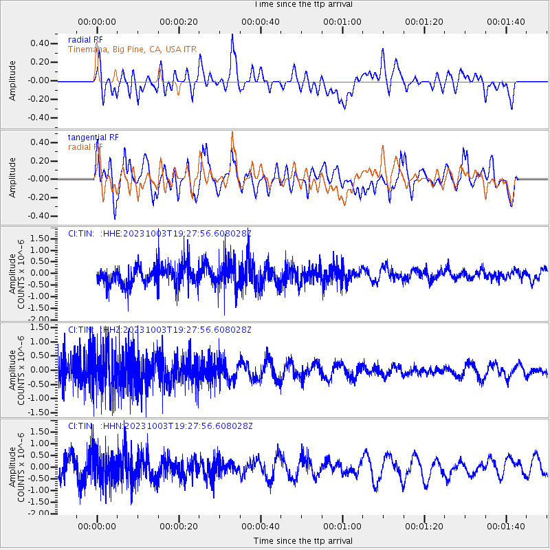
TIN Tinemaha, Big Pine, CA, USA - Earthquake Result Viewer
*The percent match for this event was below the threshold and hence no stack was calculated.
| Earthquake location: |
Bonin Islands, Japan Region |
| Earthquake latitude/longitude: |
28.4/138.8 |
| Earthquake time(UTC): |
2023/10/03 (276) 19:16:58 GMT |
| Earthquake Depth: |
517 km |
| Earthquake Magnitude: |
5.3 Mww |
| Earthquake Catalog/Contributor: |
NEIC PDE/us |
|
| Network: |
CI Caltech Regional Seismic Network |
| Station: |
TIN Tinemaha, Big Pine, CA, USA |
| Lat/Lon: |
37.05 N/118.23 W |
| Elevation: |
1197 m |
|
| Distance: |
82.8 deg |
| Az: |
51.787 deg |
| Baz: |
300.064 deg |
| Ray Param: |
$rayparam |
*The percent match for this event was below the threshold and hence was not used in the summary stack. |
|
| Radial Match: |
50.07466 % |
| Radial Bump: |
400 |
| Transverse Match: |
66.12399 % |
| Transverse Bump: |
400 |
| SOD ConfigId: |
31937991 |
| Insert Time: |
2023-10-17 19:28:48.084 +0000 |
| GWidth: |
2.5 |
| Max Bumps: |
400 |
| Tol: |
0.001 |
|
Signal To Noise
| Channel | StoN | STA | LTA |
| CI:TIN: :HHZ:20231003T19:27:56.608028Z | 2.0119724 | 7.9523517E-7 | 3.952515E-7 |
| CI:TIN: :HHN:20231003T19:27:56.608028Z | 1.6614295 | 6.823518E-7 | 4.107016E-7 |
| CI:TIN: :HHE:20231003T19:27:56.608028Z | 1.4503667 | 6.607394E-7 | 4.5556712E-7 |
| Arrivals |
| Ps | |
| PpPs | |
| PsPs/PpSs | |


