You are here: Home > Network List > G - GEOSCOPE Stations List
> Station TAM Tamanrasset, Algeria > Earthquake Result Viewer
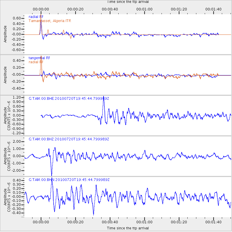
TAM Tamanrasset, Algeria - Earthquake Result Viewer
*The percent match for this event was below the threshold and hence no stack was calculated.
| Earthquake location: |
Southern Iran |
| Earthquake latitude/longitude: |
27.0/53.9 |
| Earthquake time(UTC): |
2010/07/20 (201) 19:38:09 GMT |
| Earthquake Depth: |
10 km |
| Earthquake Magnitude: |
5.6 MB, 5.8 MW, 5.8 LG |
| Earthquake Catalog/Contributor: |
WHDF/NEIC |
|
| Network: |
G GEOSCOPE |
| Station: |
TAM Tamanrasset, Algeria |
| Lat/Lon: |
22.79 N/5.53 E |
| Elevation: |
1377 m |
|
| Distance: |
43.8 deg |
| Az: |
275.497 deg |
| Baz: |
74.195 deg |
| Ray Param: |
$rayparam |
*The percent match for this event was below the threshold and hence was not used in the summary stack. |
|
| Radial Match: |
75.855446 % |
| Radial Bump: |
400 |
| Transverse Match: |
63.67871 % |
| Transverse Bump: |
400 |
| SOD ConfigId: |
319893 |
| Insert Time: |
2011-01-05 09:02:12.765 +0000 |
| GWidth: |
2.5 |
| Max Bumps: |
400 |
| Tol: |
0.001 |
|
Signal To Noise
| Channel | StoN | STA | LTA |
| G:TAM:00:BHZ:20100720T19:45:44.799989Z | 2.002878 | 3.0285352E-7 | 1.5120918E-7 |
| G:TAM:00:BHN:20100720T19:45:44.799989Z | 0.45885774 | 3.2717335E-8 | 7.13017E-8 |
| G:TAM:00:BHE:20100720T19:45:44.799989Z | 2.906836 | 1.739858E-7 | 5.985401E-8 |
| Arrivals |
| Ps | |
| PpPs | |
| PsPs/PpSs | |


