You are here: Home > Network List > US - United States National Seismic Network Stations List
> Station COWI Conover, Wisconsin, USA > Earthquake Result Viewer
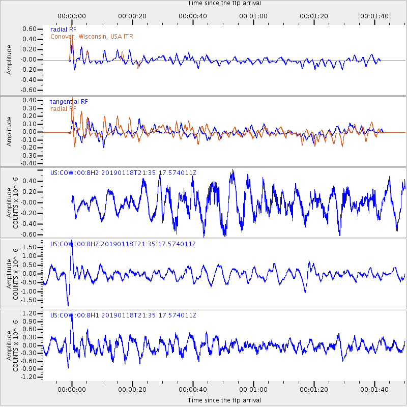
COWI Conover, Wisconsin, USA - Earthquake Result Viewer
*The percent match for this event was below the threshold and hence no stack was calculated.
| Earthquake location: |
Northern Peru |
| Earthquake latitude/longitude: |
-3.3/-76.9 |
| Earthquake time(UTC): |
2019/01/18 (018) 21:27:01 GMT |
| Earthquake Depth: |
103 km |
| Earthquake Magnitude: |
5.7 Mww |
| Earthquake Catalog/Contributor: |
NEIC PDE/us |
|
| Network: |
US United States National Seismic Network |
| Station: |
COWI Conover, Wisconsin, USA |
| Lat/Lon: |
46.10 N/89.14 W |
| Elevation: |
523 m |
|
| Distance: |
50.4 deg |
| Az: |
348.919 deg |
| Baz: |
163.992 deg |
| Ray Param: |
$rayparam |
*The percent match for this event was below the threshold and hence was not used in the summary stack. |
|
| Radial Match: |
59.341167 % |
| Radial Bump: |
400 |
| Transverse Match: |
57.390022 % |
| Transverse Bump: |
389 |
| SOD ConfigId: |
3260311 |
| Insert Time: |
2019-02-01 21:46:55.859 +0000 |
| GWidth: |
2.5 |
| Max Bumps: |
400 |
| Tol: |
0.001 |
|
Signal To Noise
| Channel | StoN | STA | LTA |
| US:COWI:00:BHZ:20190118T21:35:17.574011Z | 2.8720143 | 6.802033E-7 | 2.3683842E-7 |
| US:COWI:00:BH1:20190118T21:35:17.574011Z | 2.663038 | 4.4441222E-7 | 1.6688168E-7 |
| US:COWI:00:BH2:20190118T21:35:17.574011Z | 1.7920346 | 2.8525739E-7 | 1.5918074E-7 |
| Arrivals |
| Ps | |
| PpPs | |
| PsPs/PpSs | |


