You are here: Home > Network List > AV - Alaska Volcano Observatory Stations List
> Station AMKA Regional Station, Amchitka Island, Alaska > Earthquake Result Viewer
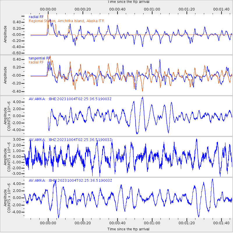
AMKA Regional Station, Amchitka Island, Alaska - Earthquake Result Viewer
*The percent match for this event was below the threshold and hence no stack was calculated.
| Earthquake location: |
Southeast Of Honshu, Japan |
| Earthquake latitude/longitude: |
30.0/140.2 |
| Earthquake time(UTC): |
2023/10/04 (277) 02:19:06 GMT |
| Earthquake Depth: |
8.0 km |
| Earthquake Magnitude: |
5.6 mww |
| Earthquake Catalog/Contributor: |
NEIC PDE/us |
|
| Network: |
AV Alaska Volcano Observatory |
| Station: |
AMKA Regional Station, Amchitka Island, Alaska |
| Lat/Lon: |
51.38 N/179.30 E |
| Elevation: |
116 m |
|
| Distance: |
36.0 deg |
| Az: |
42.273 deg |
| Baz: |
248.663 deg |
| Ray Param: |
$rayparam |
*The percent match for this event was below the threshold and hence was not used in the summary stack. |
|
| Radial Match: |
47.436993 % |
| Radial Bump: |
400 |
| Transverse Match: |
58.5558 % |
| Transverse Bump: |
390 |
| SOD ConfigId: |
31937991 |
| Insert Time: |
2023-10-18 02:23:29.834 +0000 |
| GWidth: |
2.5 |
| Max Bumps: |
400 |
| Tol: |
0.001 |
|
Signal To Noise
| Channel | StoN | STA | LTA |
| AV:AMKA: :BHZ:20231004T02:25:36.519003Z | 1.037992 | 1.0976687E-6 | 1.0574925E-6 |
| AV:AMKA: :BHN:20231004T02:25:36.519003Z | 2.8192809 | 2.8799238E-6 | 1.0215101E-6 |
| AV:AMKA: :BHE:20231004T02:25:36.519003Z | 0.7386698 | 1.0629559E-6 | 1.4390135E-6 |
| Arrivals |
| Ps | |
| PpPs | |
| PsPs/PpSs | |


