You are here: Home > Network List > GS - US Geological Survey Networks Stations List
> Station OK051 E0350 and S34600 roads, Ralston OK > Earthquake Result Viewer
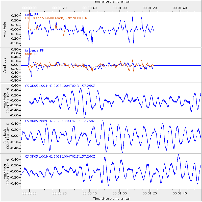
OK051 E0350 and S34600 roads, Ralston OK - Earthquake Result Viewer
*The percent match for this event was below the threshold and hence no stack was calculated.
| Earthquake location: |
Southeast Of Honshu, Japan |
| Earthquake latitude/longitude: |
30.0/140.2 |
| Earthquake time(UTC): |
2023/10/04 (277) 02:19:06 GMT |
| Earthquake Depth: |
8.0 km |
| Earthquake Magnitude: |
5.6 mww |
| Earthquake Catalog/Contributor: |
NEIC PDE/us |
|
| Network: |
GS US Geological Survey Networks |
| Station: |
OK051 E0350 and S34600 roads, Ralston OK |
| Lat/Lon: |
36.50 N/96.84 W |
| Elevation: |
263 m |
|
| Distance: |
94.9 deg |
| Az: |
42.746 deg |
| Baz: |
313.021 deg |
| Ray Param: |
$rayparam |
*The percent match for this event was below the threshold and hence was not used in the summary stack. |
|
| Radial Match: |
36.981655 % |
| Radial Bump: |
400 |
| Transverse Match: |
60.98762 % |
| Transverse Bump: |
400 |
| SOD ConfigId: |
31937991 |
| Insert Time: |
2023-10-18 02:31:02.533 +0000 |
| GWidth: |
2.5 |
| Max Bumps: |
400 |
| Tol: |
0.001 |
|
Signal To Noise
| Channel | StoN | STA | LTA |
| GS:OK051:00:HHZ:20231004T02:31:57.260Z | 0.53229016 | 9.1362324E-8 | 1.7164007E-7 |
| GS:OK051:00:HH1:20231004T02:31:57.260Z | 0.42144555 | 7.101725E-8 | 1.6850872E-7 |
| GS:OK051:00:HH2:20231004T02:31:57.260Z | 2.862324 | 3.4490495E-7 | 1.2049821E-7 |
| Arrivals |
| Ps | |
| PpPs | |
| PsPs/PpSs | |


