You are here: Home > Network List > US - United States National Seismic Network Stations List
> Station HAWA Hanford, Washington, USA > Earthquake Result Viewer
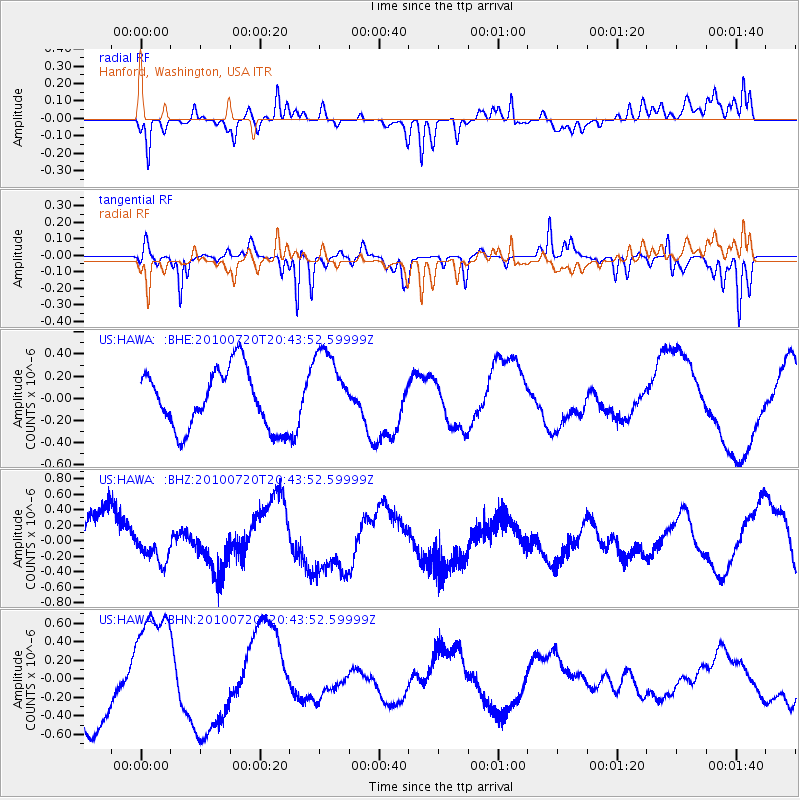
HAWA Hanford, Washington, USA - Earthquake Result Viewer
*The percent match for this event was below the threshold and hence no stack was calculated.
| Earthquake location: |
New Britain Region, P.N.G. |
| Earthquake latitude/longitude: |
-6.0/150.7 |
| Earthquake time(UTC): |
2010/07/20 (201) 20:31:08 GMT |
| Earthquake Depth: |
35 km |
| Earthquake Magnitude: |
5.5 MS, 5.3 MB, 5.6 MW |
| Earthquake Catalog/Contributor: |
WHDF/NEIC |
|
| Network: |
US United States National Seismic Network |
| Station: |
HAWA Hanford, Washington, USA |
| Lat/Lon: |
46.39 N/119.53 W |
| Elevation: |
364 m |
|
| Distance: |
94.2 deg |
| Az: |
43.944 deg |
| Baz: |
265.692 deg |
| Ray Param: |
$rayparam |
*The percent match for this event was below the threshold and hence was not used in the summary stack. |
|
| Radial Match: |
62.703304 % |
| Radial Bump: |
367 |
| Transverse Match: |
79.62533 % |
| Transverse Bump: |
367 |
| SOD ConfigId: |
319893 |
| Insert Time: |
2011-01-05 09:09:46.958 +0000 |
| GWidth: |
2.5 |
| Max Bumps: |
400 |
| Tol: |
0.001 |
|
Signal To Noise
| Channel | StoN | STA | LTA |
| US:HAWA: :BHZ:20100720T20:43:52.59999Z | 0.4342806 | 1.9585123E-7 | 4.5097852E-7 |
| US:HAWA: :BHN:20100720T20:43:52.59999Z | 2.0619054 | 6.7391363E-7 | 3.268402E-7 |
| US:HAWA: :BHE:20100720T20:43:52.59999Z | 1.3566766 | 3.585066E-7 | 2.6425354E-7 |
| Arrivals |
| Ps | |
| PpPs | |
| PsPs/PpSs | |


