You are here: Home > Network List > CN - Canadian National Seismograph Network Stations List
> Station INK INUVIK, NT > Earthquake Result Viewer
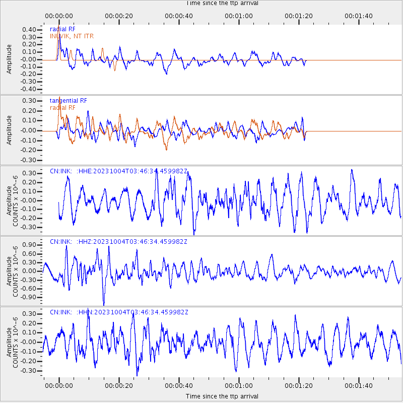
INK INUVIK, NT - Earthquake Result Viewer
*The percent match for this event was below the threshold and hence no stack was calculated.
| Earthquake location: |
Philippine Islands Region |
| Earthquake latitude/longitude: |
19.2/121.2 |
| Earthquake time(UTC): |
2023/10/04 (277) 03:35:10 GMT |
| Earthquake Depth: |
27 km |
| Earthquake Magnitude: |
5.7 Mww |
| Earthquake Catalog/Contributor: |
NEIC PDE/us |
|
| Network: |
CN Canadian National Seismograph Network |
| Station: |
INK INUVIK, NT |
| Lat/Lon: |
68.31 N/133.53 W |
| Elevation: |
44 m |
|
| Distance: |
77.8 deg |
| Az: |
21.529 deg |
| Baz: |
291.119 deg |
| Ray Param: |
$rayparam |
*The percent match for this event was below the threshold and hence was not used in the summary stack. |
|
| Radial Match: |
71.97572 % |
| Radial Bump: |
373 |
| Transverse Match: |
45.73133 % |
| Transverse Bump: |
400 |
| SOD ConfigId: |
31937991 |
| Insert Time: |
2023-10-18 03:45:44.722 +0000 |
| GWidth: |
2.5 |
| Max Bumps: |
400 |
| Tol: |
0.001 |
|
Signal To Noise
| Channel | StoN | STA | LTA |
| CN:INK: :HHZ:20231004T03:46:34.459982Z | 2.8150098 | 3.739939E-7 | 1.3285705E-7 |
| CN:INK: :HHN:20231004T03:46:34.459982Z | 0.91196364 | 1.0134745E-7 | 1.1113102E-7 |
| CN:INK: :HHE:20231004T03:46:34.459982Z | 1.5403749 | 1.7903189E-7 | 1.16226175E-7 |
| Arrivals |
| Ps | |
| PpPs | |
| PsPs/PpSs | |


