You are here: Home > Network List > IC - New China Digital Seismograph Network Stations List
> Station LSA Tibet, China > Earthquake Result Viewer
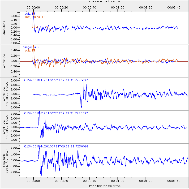
LSA Tibet, China - Earthquake Result Viewer
*The percent match for this event was below the threshold and hence no stack was calculated.
| Earthquake location: |
North Of Halmahera, Indonesia |
| Earthquake latitude/longitude: |
3.0/128.2 |
| Earthquake time(UTC): |
2010/07/21 (202) 09:16:04 GMT |
| Earthquake Depth: |
100 km |
| Earthquake Magnitude: |
6.0 MB, 6.1 MW, 6.1 MW |
| Earthquake Catalog/Contributor: |
WHDF/NEIC |
|
| Network: |
IC New China Digital Seismograph Network |
| Station: |
LSA Tibet, China |
| Lat/Lon: |
29.70 N/91.15 E |
| Elevation: |
3789 m |
|
| Distance: |
44.0 deg |
| Az: |
310.986 deg |
| Baz: |
119.957 deg |
| Ray Param: |
$rayparam |
*The percent match for this event was below the threshold and hence was not used in the summary stack. |
|
| Radial Match: |
77.40022 % |
| Radial Bump: |
400 |
| Transverse Match: |
68.569305 % |
| Transverse Bump: |
400 |
| SOD ConfigId: |
319893 |
| Insert Time: |
2011-01-05 09:14:01.817 +0000 |
| GWidth: |
2.5 |
| Max Bumps: |
400 |
| Tol: |
0.001 |
|
Signal To Noise
| Channel | StoN | STA | LTA |
| IC:LSA:00:BHZ:20100721T09:23:31.723009Z | 35.462696 | 4.098564E-6 | 1.1557396E-7 |
| IC:LSA:00:BHN:20100721T09:23:31.723009Z | 22.590492 | 8.5640977E-7 | 3.7910187E-8 |
| IC:LSA:00:BHE:20100721T09:23:31.723009Z | 14.467537 | 1.95107E-6 | 1.348585E-7 |
| Arrivals |
| Ps | |
| PpPs | |
| PsPs/PpSs | |


