You are here: Home > Network List > IU - Global Seismograph Network (GSN - IRIS/USGS) Stations List
> Station XMAS Kiritimati Island, Republic of Kiribati > Earthquake Result Viewer
XMAS Kiritimati Island, Republic of Kiribati - Earthquake Result Viewer

| Earthquake location: |
North Of Halmahera, Indonesia |
| Earthquake latitude/longitude: |
3.0/128.2 |
| Earthquake time(UTC): |
2010/07/21 (202) 09:16:04 GMT |
| Earthquake Depth: |
100 km |
| Earthquake Magnitude: |
6.0 MB, 6.1 MW, 6.1 MW |
| Earthquake Catalog/Contributor: |
WHDF/NEIC |
|
| Network: |
IU Global Seismograph Network (GSN - IRIS/USGS) |
| Station: |
XMAS Kiritimati Island, Republic of Kiribati |
| Lat/Lon: |
2.04 N/157.45 W |
| Elevation: |
20 m |
|
| Distance: |
74.3 deg |
| Az: |
88.739 deg |
| Baz: |
272.565 deg |
| Ray Param: |
0.052218873 |
| Estimated Moho Depth: |
43.5 km |
| Estimated Crust Vp/Vs: |
1.86 |
| Assumed Crust Vp: |
4.802 km/s |
| Estimated Crust Vs: |
2.589 km/s |
| Estimated Crust Poisson's Ratio: |
0.30 |
|
| Radial Match: |
99.092766 % |
| Radial Bump: |
68 |
| Transverse Match: |
99.69442 % |
| Transverse Bump: |
50 |
| SOD ConfigId: |
319893 |
| Insert Time: |
2011-01-05 09:14:35.931 +0000 |
| GWidth: |
2.5 |
| Max Bumps: |
400 |
| Tol: |
0.001 |
|
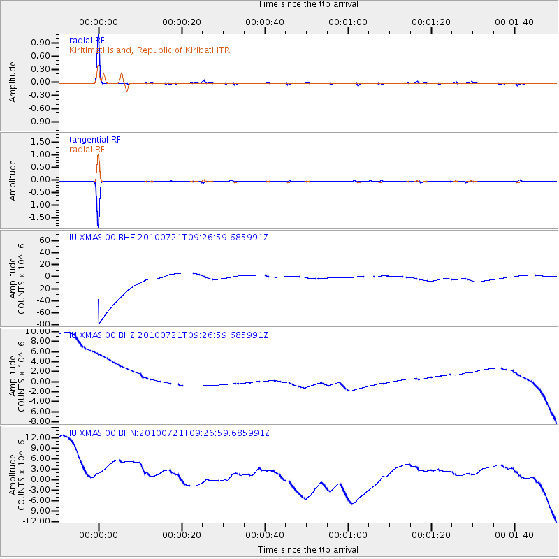
Signal To Noise
| Channel | StoN | STA | LTA |
| IU:XMAS:00:BHZ:20100721T09:26:59.685991Z | 0.7082287 | 2.134251E-5 | 3.0135056E-5 |
| IU:XMAS:00:BHN:20100721T09:26:59.685991Z | 0.65076035 | 2.4849278E-5 | 3.818499E-5 |
| IU:XMAS:00:BHE:20100721T09:26:59.685991Z | 0.6033876 | 1.4539997E-5 | 2.4097277E-5 |
| Arrivals |
| Ps | 7.9 SECOND |
| PpPs | 25 SECOND |
| PsPs/PpSs | 33 SECOND |


