You are here: Home > Network List > IU - Global Seismograph Network (GSN - IRIS/USGS) Stations List
> Station FURI Mt. Furi, Ethiopia > Earthquake Result Viewer
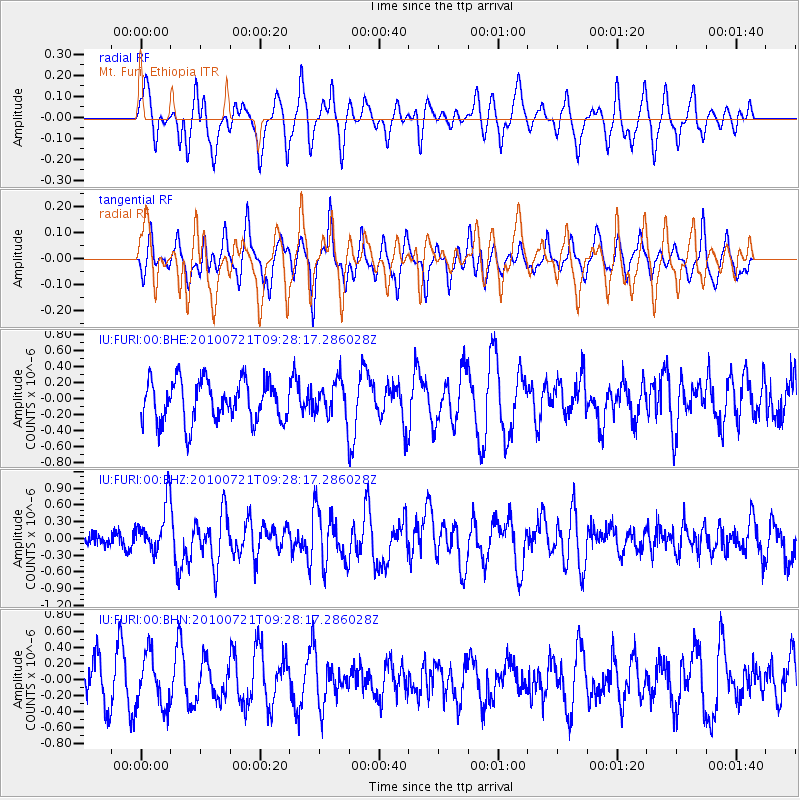
FURI Mt. Furi, Ethiopia - Earthquake Result Viewer
*The percent match for this event was below the threshold and hence no stack was calculated.
| Earthquake location: |
North Of Halmahera, Indonesia |
| Earthquake latitude/longitude: |
3.0/128.2 |
| Earthquake time(UTC): |
2010/07/21 (202) 09:16:04 GMT |
| Earthquake Depth: |
100 km |
| Earthquake Magnitude: |
6.0 MB, 6.1 MW, 6.1 MW |
| Earthquake Catalog/Contributor: |
WHDF/NEIC |
|
| Network: |
IU Global Seismograph Network (GSN - IRIS/USGS) |
| Station: |
FURI Mt. Furi, Ethiopia |
| Lat/Lon: |
8.90 N/38.68 E |
| Elevation: |
2570 m |
|
| Distance: |
89.1 deg |
| Az: |
278.801 deg |
| Baz: |
87.087 deg |
| Ray Param: |
$rayparam |
*The percent match for this event was below the threshold and hence was not used in the summary stack. |
|
| Radial Match: |
69.588196 % |
| Radial Bump: |
400 |
| Transverse Match: |
60.2799 % |
| Transverse Bump: |
400 |
| SOD ConfigId: |
319893 |
| Insert Time: |
2011-01-05 09:14:44.840 +0000 |
| GWidth: |
2.5 |
| Max Bumps: |
400 |
| Tol: |
0.001 |
|
Signal To Noise
| Channel | StoN | STA | LTA |
| IU:FURI:00:BHZ:20100721T09:28:17.286028Z | 2.185081 | 4.422969E-7 | 2.024167E-7 |
| IU:FURI:00:BHN:20100721T09:28:17.286028Z | 1.322421 | 3.1833594E-7 | 2.407221E-7 |
| IU:FURI:00:BHE:20100721T09:28:17.286028Z | 0.8455608 | 2.1543062E-7 | 2.5477837E-7 |
| Arrivals |
| Ps | |
| PpPs | |
| PsPs/PpSs | |


