You are here: Home > Network List > JP - Japan Meteorological Agency Seismic Network Stations List
> Station ASAJ Kamikawa Asahi > Earthquake Result Viewer
ASAJ Kamikawa Asahi - Earthquake Result Viewer
| Earthquake location: |
North Of Halmahera, Indonesia |
| Earthquake latitude/longitude: |
3.0/128.2 |
| Earthquake time(UTC): |
2010/07/21 (202) 09:16:04 GMT |
| Earthquake Depth: |
100 km |
| Earthquake Magnitude: |
6.0 MB, 6.1 MW, 6.1 MW |
| Earthquake Catalog/Contributor: |
WHDF/NEIC |
|
| Network: |
JP Japan Meteorological Agency Seismic Network |
| Station: |
ASAJ Kamikawa Asahi |
| Lat/Lon: |
44.12 N/142.59 E |
| Elevation: |
220 m |
|
| Distance: |
42.8 deg |
| Az: |
15.242 deg |
| Baz: |
201.378 deg |
| Ray Param: |
0.07258564 |
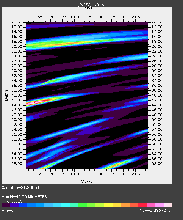
| Estimated Moho Depth: |
42.75 km |
| Estimated Crust Vp/Vs: |
1.63 |
| Assumed Crust Vp: |
6.183 km/s |
| Estimated Crust Vs: |
3.781 km/s |
| Estimated Crust Poisson's Ratio: |
0.20 |
|
| Radial Match: |
81.869545 % |
| Radial Bump: |
400 |
| Transverse Match: |
76.46643 % |
| Transverse Bump: |
400 |
| SOD ConfigId: |
319893 |
| Insert Time: |
2011-01-05 09:14:45.252 +0000 |
| GWidth: |
2.5 |
| Max Bumps: |
400 |
| Tol: |
0.001 |
|

Signal To Noise
| Channel | StoN | STA | LTA |
| JP:ASAJ: :BHZ:20100721T09:23:22.150011Z | 18.945808 | 2.3047774E-6 | 1.2165104E-7 |
| JP:ASAJ: :BHN:20100721T09:23:22.150011Z | 6.837436 | 9.162952E-7 | 1.3401151E-7 |
| JP:ASAJ: :BHE:20100721T09:23:22.150011Z | 10.573363 | 1.0527775E-6 | 9.9568844E-8 |
| Arrivals |
| Ps | 4.7 SECOND |
| PpPs | 17 SECOND |
| PsPs/PpSs | 22 SECOND |


