You are here: Home > Network List > GS - US Geological Survey Networks Stations List
> Station OK051 E0350 and S34600 roads, Ralston OK > Earthquake Result Viewer
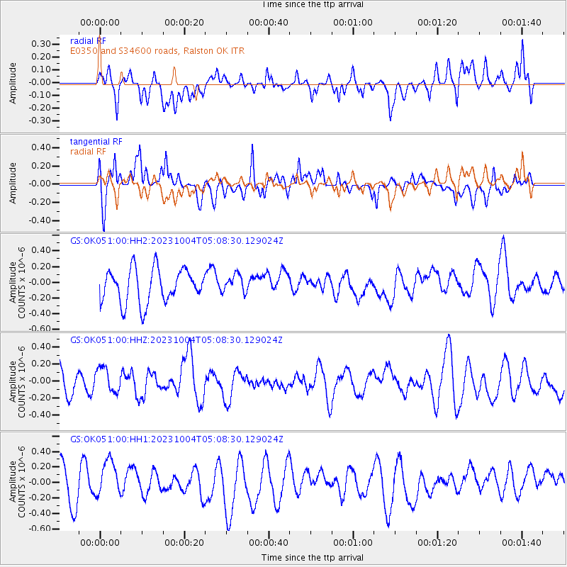
OK051 E0350 and S34600 roads, Ralston OK - Earthquake Result Viewer
*The percent match for this event was below the threshold and hence no stack was calculated.
| Earthquake location: |
Southeast Of Honshu, Japan |
| Earthquake latitude/longitude: |
31.1/141.9 |
| Earthquake time(UTC): |
2023/10/04 (277) 04:55:47 GMT |
| Earthquake Depth: |
10 km |
| Earthquake Magnitude: |
5.7 mww |
| Earthquake Catalog/Contributor: |
NEIC PDE/us |
|
| Network: |
GS US Geological Survey Networks |
| Station: |
OK051 E0350 and S34600 roads, Ralston OK |
| Lat/Lon: |
36.50 N/96.84 W |
| Elevation: |
263 m |
|
| Distance: |
93.1 deg |
| Az: |
43.6 deg |
| Baz: |
312.74 deg |
| Ray Param: |
$rayparam |
*The percent match for this event was below the threshold and hence was not used in the summary stack. |
|
| Radial Match: |
59.693985 % |
| Radial Bump: |
400 |
| Transverse Match: |
71.1995 % |
| Transverse Bump: |
400 |
| SOD ConfigId: |
31937991 |
| Insert Time: |
2023-10-18 05:09:03.591 +0000 |
| GWidth: |
2.5 |
| Max Bumps: |
400 |
| Tol: |
0.001 |
|
Signal To Noise
| Channel | StoN | STA | LTA |
| GS:OK051:00:HHZ:20231004T05:08:30.129024Z | 1.0311142 | 1.4743027E-7 | 1.429815E-7 |
| GS:OK051:00:HH1:20231004T05:08:30.129024Z | 1.2032355 | 2.4646965E-7 | 2.0483908E-7 |
| GS:OK051:00:HH2:20231004T05:08:30.129024Z | 0.539626 | 1.161112E-7 | 2.1516978E-7 |
| Arrivals |
| Ps | |
| PpPs | |
| PsPs/PpSs | |


