You are here: Home > Network List > AV - Alaska Volcano Observatory Stations List
> Station SPCN Ckakachatna North Broadband, Mount Spurr, Alaska > Earthquake Result Viewer
SPCN Ckakachatna North Broadband, Mount Spurr, Alaska - Earthquake Result Viewer
| Earthquake location: |
Southeast Of Honshu, Japan |
| Earthquake latitude/longitude: |
30.8/142.0 |
| Earthquake time(UTC): |
2023/10/04 (277) 05:57:17 GMT |
| Earthquake Depth: |
10 km |
| Earthquake Magnitude: |
5.6 mww |
| Earthquake Catalog/Contributor: |
NEIC PDE/us |
|
| Network: |
AV Alaska Volcano Observatory |
| Station: |
SPCN Ckakachatna North Broadband, Mount Spurr, Alaska |
| Lat/Lon: |
61.22 N/152.19 W |
| Elevation: |
735 m |
|
| Distance: |
51.9 deg |
| Az: |
34.088 deg |
| Baz: |
265.438 deg |
| Ray Param: |
0.06709103 |
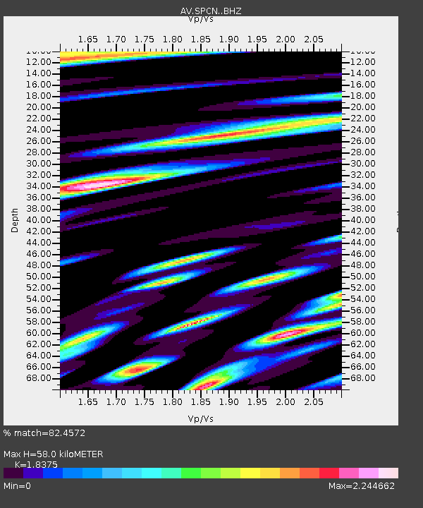
| Estimated Moho Depth: |
58.0 km |
| Estimated Crust Vp/Vs: |
1.84 |
| Assumed Crust Vp: |
6.566 km/s |
| Estimated Crust Vs: |
3.573 km/s |
| Estimated Crust Poisson's Ratio: |
0.29 |
|
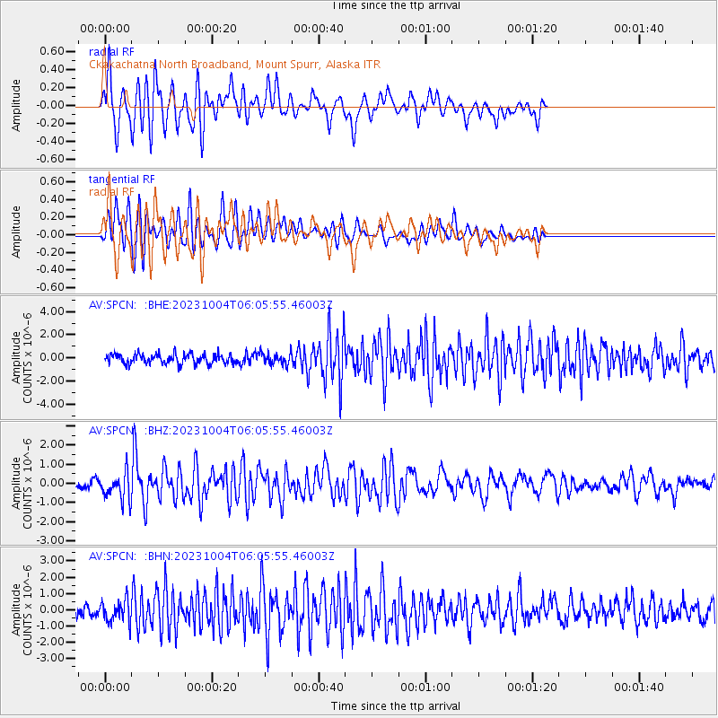
| Radial Match: |
82.4572 % |
| Radial Bump: |
400 |
| Transverse Match: |
81.589195 % |
| Transverse Bump: |
400 |
| SOD ConfigId: |
31937991 |
| Insert Time: |
2023-10-18 06:04:31.148 +0000 |
| GWidth: |
2.5 |
| Max Bumps: |
400 |
| Tol: |
0.001 |
|
Signal To Noise
| Channel | StoN | STA | LTA |
| AV:SPCN: :BHZ:20231004T06:05:55.46003Z | 3.2397797 | 6.8294963E-7 | 2.1080125E-7 |
| AV:SPCN: :BHN:20231004T06:05:55.46003Z | 1.8419753 | 6.6788647E-7 | 3.6259252E-7 |
| AV:SPCN: :BHE:20231004T06:05:55.46003Z | 1.1978562 | 5.0421113E-7 | 4.2092796E-7 |
| Arrivals |
| Ps | 7.8 SECOND |
| PpPs | 24 SECOND |
| PsPs/PpSs | 32 SECOND |


