You are here: Home > Network List > QZ - Seismic network of the Seismological Experience and Methodology Expedition CS ME Stations List
> Station INDER Inderbor Kazakhstan (SNECCA) > Earthquake Result Viewer
INDER Inderbor Kazakhstan (SNECCA) - Earthquake Result Viewer
| Earthquake location: |
Southeast Of Honshu, Japan |
| Earthquake latitude/longitude: |
30.8/142.0 |
| Earthquake time(UTC): |
2023/10/04 (277) 05:57:17 GMT |
| Earthquake Depth: |
10 km |
| Earthquake Magnitude: |
5.6 mww |
| Earthquake Catalog/Contributor: |
NEIC PDE/us |
|
| Network: |
QZ Seismic network of the Seismological Experience and Methodology Expedition CS ME |
| Station: |
INDER Inderbor Kazakhstan (SNECCA) |
| Lat/Lon: |
48.50 N/51.69 E |
| Elevation: |
-19.0 m |
|
| Distance: |
67.9 deg |
| Az: |
314.109 deg |
| Baz: |
68.291 deg |
| Ray Param: |
0.056688856 |
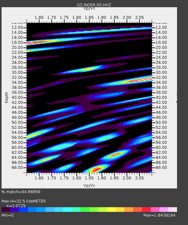
| Estimated Moho Depth: |
32.5 km |
| Estimated Crust Vp/Vs: |
2.07 |
| Assumed Crust Vp: |
5.79 km/s |
| Estimated Crust Vs: |
2.794 km/s |
| Estimated Crust Poisson's Ratio: |
0.35 |
|
| Radial Match: |
84.96959 % |
| Radial Bump: |
400 |
| Transverse Match: |
76.405136 % |
| Transverse Bump: |
400 |
| SOD ConfigId: |
31937991 |
| Insert Time: |
2023-10-18 06:18:16.832 +0000 |
| GWidth: |
2.5 |
| Max Bumps: |
400 |
| Tol: |
0.001 |
|

Signal To Noise
| Channel | StoN | STA | LTA |
| QZ:INDER:00:HHZ:20231004T06:07:44.70002Z | 3.5436964 | 7.5117543E-7 | 2.119751E-7 |
| QZ:INDER:00:HHN:20231004T06:07:44.70002Z | 1.6178938 | 3.362305E-7 | 2.0781988E-7 |
| QZ:INDER:00:HHE:20231004T06:07:44.70002Z | 1.5870242 | 4.6269255E-7 | 2.9154725E-7 |
| Arrivals |
| Ps | 6.2 SECOND |
| PpPs | 17 SECOND |
| PsPs/PpSs | 23 SECOND |


