You are here: Home > Network List > AK - Alaska Regional Network Stations List
> Station F20K Avaraart Lake, AK, USA > Earthquake Result Viewer
F20K Avaraart Lake, AK, USA - Earthquake Result Viewer
| Earthquake location: |
Mindanao, Philippines |
| Earthquake latitude/longitude: |
5.3/126.1 |
| Earthquake time(UTC): |
2023/10/04 (277) 11:21:48 GMT |
| Earthquake Depth: |
122 km |
| Earthquake Magnitude: |
6.4 mww |
| Earthquake Catalog/Contributor: |
NEIC PDE/us |
|
| Network: |
AK Alaska Regional Network |
| Station: |
F20K Avaraart Lake, AK, USA |
| Lat/Lon: |
67.05 N/155.73 W |
| Elevation: |
136 m |
|
| Distance: |
80.5 deg |
| Az: |
22.907 deg |
| Baz: |
261.205 deg |
| Ray Param: |
0.047950737 |
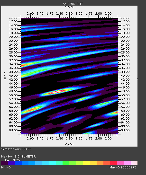
| Estimated Moho Depth: |
48.0 km |
| Estimated Crust Vp/Vs: |
1.78 |
| Assumed Crust Vp: |
6.522 km/s |
| Estimated Crust Vs: |
3.659 km/s |
| Estimated Crust Poisson's Ratio: |
0.27 |
|
| Radial Match: |
90.00405 % |
| Radial Bump: |
400 |
| Transverse Match: |
88.36447 % |
| Transverse Bump: |
400 |
| SOD ConfigId: |
31937991 |
| Insert Time: |
2023-10-18 11:25:44.272 +0000 |
| GWidth: |
2.5 |
| Max Bumps: |
400 |
| Tol: |
0.001 |
|

Signal To Noise
| Channel | StoN | STA | LTA |
| AK:F20K: :BHZ:20231004T11:33:16.000026Z | 21.709248 | 2.7750127E-6 | 1.278263E-7 |
| AK:F20K: :BHN:20231004T11:33:16.000026Z | 4.0444617 | 5.1223594E-7 | 1.266512E-7 |
| AK:F20K: :BHE:20231004T11:33:16.000026Z | 12.6672 | 1.3770289E-6 | 1.0870823E-7 |
| Arrivals |
| Ps | 5.9 SECOND |
| PpPs | 20 SECOND |
| PsPs/PpSs | 26 SECOND |


