You are here: Home > Network List > AV - Alaska Volcano Observatory Stations List
> Station R17L Mt. Peulik Volcano, AVO PLK4, AK, USA > Earthquake Result Viewer
R17L Mt. Peulik Volcano, AVO PLK4, AK, USA - Earthquake Result Viewer
| Earthquake location: |
Mindanao, Philippines |
| Earthquake latitude/longitude: |
5.3/126.1 |
| Earthquake time(UTC): |
2023/10/04 (277) 11:21:48 GMT |
| Earthquake Depth: |
122 km |
| Earthquake Magnitude: |
6.4 mww |
| Earthquake Catalog/Contributor: |
NEIC PDE/us |
|
| Network: |
AV Alaska Volcano Observatory |
| Station: |
R17L Mt. Peulik Volcano, AVO PLK4, AK, USA |
| Lat/Lon: |
57.63 N/156.36 W |
| Elevation: |
524 m |
|
| Distance: |
78.9 deg |
| Az: |
32.373 deg |
| Baz: |
262.341 deg |
| Ray Param: |
0.049075015 |
| Estimated Moho Depth: |
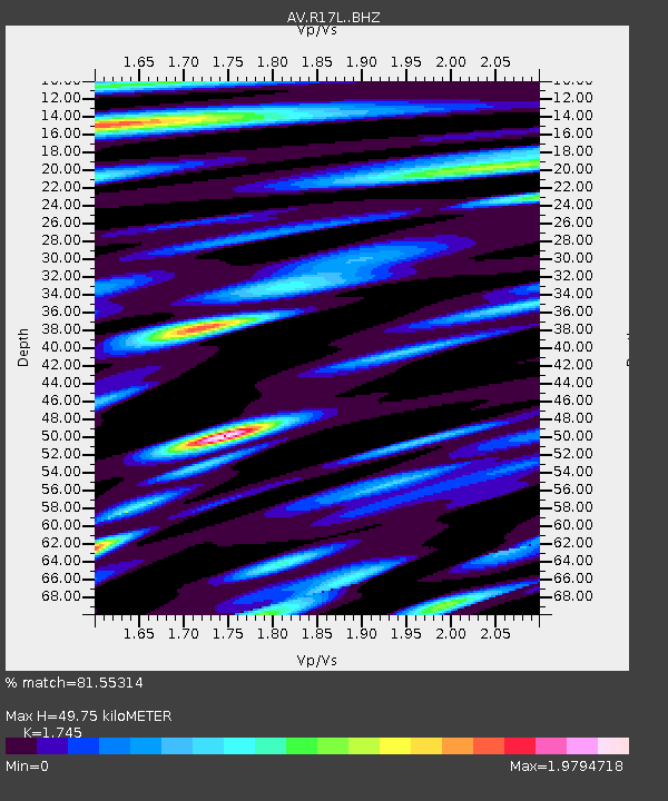
49.75 km |
| Estimated Crust Vp/Vs: |
1.75 |
| Assumed Crust Vp: |
6.1 km/s |
| Estimated Crust Vs: |
3.496 km/s |
| Estimated Crust Poisson's Ratio: |
0.26 |
|
| Radial Match: |
81.55314 % |
| Radial Bump: |
400 |
| Transverse Match: |
71.3032 % |
| Transverse Bump: |
400 |
| SOD ConfigId: |
31937991 |
| Insert Time: |
2023-10-18 11:32:44.662 +0000 |
| GWidth: |
2.5 |
| Max Bumps: |
400 |
| Tol: |
0.001 |
|

Signal To Noise
| Channel | StoN | STA | LTA |
| AV:R17L: :BHZ:20231004T11:33:07.125026Z | 9.240613 | 3.1497898E-6 | 3.4086375E-7 |
| AV:R17L: :BHN:20231004T11:33:07.125026Z | 3.6980448 | 1.2972546E-6 | 3.5079472E-7 |
| AV:R17L: :BHE:20231004T11:33:07.125026Z | 4.9410157 | 2.0489977E-6 | 4.1469158E-7 |
| Arrivals |
| Ps | 6.2 SECOND |
| PpPs | 22 SECOND |
| PsPs/PpSs | 28 SECOND |


