You are here: Home > Network List > G - GEOSCOPE Stations List
> Station ATD Arta Cave - Arta, Republic of Djibouti > Earthquake Result Viewer
ATD Arta Cave - Arta, Republic of Djibouti - Earthquake Result Viewer
| Earthquake location: |
Mindanao, Philippines |
| Earthquake latitude/longitude: |
5.3/126.1 |
| Earthquake time(UTC): |
2023/10/04 (277) 11:21:48 GMT |
| Earthquake Depth: |
122 km |
| Earthquake Magnitude: |
6.4 mww |
| Earthquake Catalog/Contributor: |
NEIC PDE/us |
|
| Network: |
G GEOSCOPE |
| Station: |
ATD Arta Cave - Arta, Republic of Djibouti |
| Lat/Lon: |
11.53 N/42.85 E |
| Elevation: |
610 m |
|
| Distance: |
82.3 deg |
| Az: |
280.879 deg |
| Baz: |
86.108 deg |
| Ray Param: |
0.04670365 |
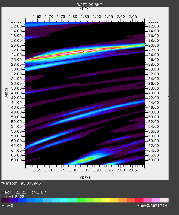
| Estimated Moho Depth: |
22.25 km |
| Estimated Crust Vp/Vs: |
1.84 |
| Assumed Crust Vp: |
6.375 km/s |
| Estimated Crust Vs: |
3.46 km/s |
| Estimated Crust Poisson's Ratio: |
0.29 |
|
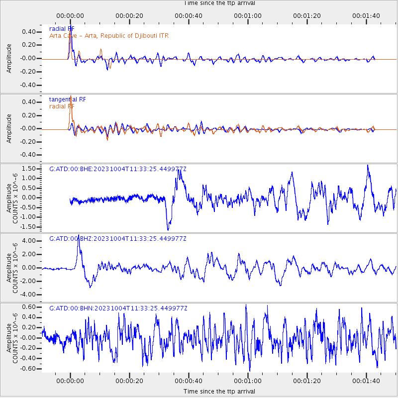
| Radial Match: |
93.876945 % |
| Radial Bump: |
400 |
| Transverse Match: |
76.63866 % |
| Transverse Bump: |
400 |
| SOD ConfigId: |
31937991 |
| Insert Time: |
2023-10-18 11:34:51.175 +0000 |
| GWidth: |
2.5 |
| Max Bumps: |
400 |
| Tol: |
0.001 |
|
Signal To Noise
| Channel | StoN | STA | LTA |
| G:ATD:00:BHZ:20231004T11:33:25.449977Z | 24.98525 | 1.8238113E-6 | 7.299552E-8 |
| G:ATD:00:BHN:20231004T11:33:25.449977Z | 1.828398 | 1.518011E-7 | 8.30241E-8 |
| G:ATD:00:BHE:20231004T11:33:25.449977Z | 6.8157625 | 7.2027177E-7 | 1.0567736E-7 |
| Arrivals |
| Ps | 3.0 SECOND |
| PpPs | 9.7 SECOND |
| PsPs/PpSs | 13 SECOND |


