You are here: Home > Network List > MM - Myanmar National Seismic Network Stations List
> Station KTN Keng Tun, Shan, Myanmar > Earthquake Result Viewer
KTN Keng Tun, Shan, Myanmar - Earthquake Result Viewer
| Earthquake location: |
Mindanao, Philippines |
| Earthquake latitude/longitude: |
5.3/126.1 |
| Earthquake time(UTC): |
2023/10/04 (277) 11:21:48 GMT |
| Earthquake Depth: |
122 km |
| Earthquake Magnitude: |
6.4 mww |
| Earthquake Catalog/Contributor: |
NEIC PDE/us |
|
| Network: |
MM Myanmar National Seismic Network |
| Station: |
KTN Keng Tun, Shan, Myanmar |
| Lat/Lon: |
21.29 N/99.59 E |
| Elevation: |
832 m |
|
| Distance: |
30.2 deg |
| Az: |
304.168 deg |
| Baz: |
117.946 deg |
| Ray Param: |
0.079253085 |
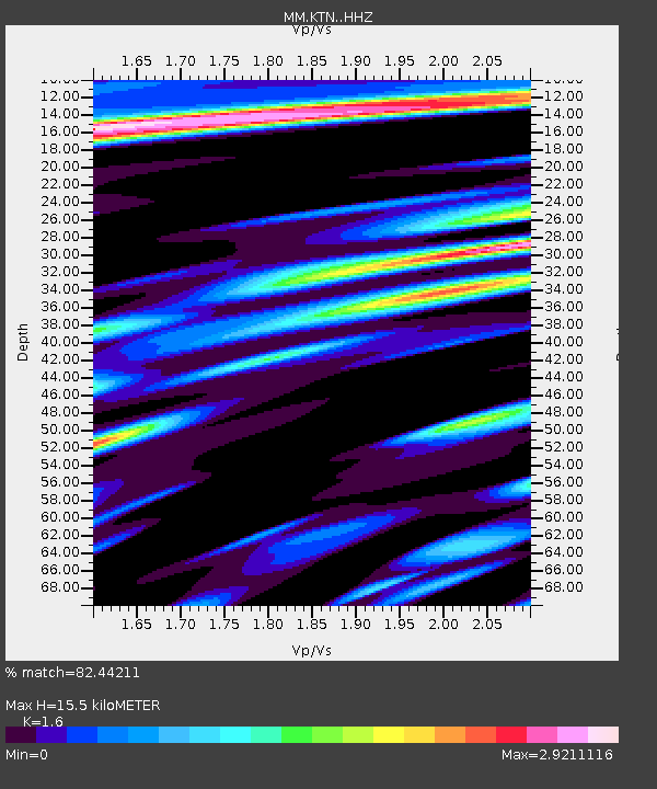
| Estimated Moho Depth: |
15.5 km |
| Estimated Crust Vp/Vs: |
1.60 |
| Assumed Crust Vp: |
6.316 km/s |
| Estimated Crust Vs: |
3.947 km/s |
| Estimated Crust Poisson's Ratio: |
0.18 |
|
| Radial Match: |
82.44211 % |
| Radial Bump: |
400 |
| Transverse Match: |
73.68578 % |
| Transverse Bump: |
396 |
| SOD ConfigId: |
31937991 |
| Insert Time: |
2023-10-18 11:38:31.686 +0000 |
| GWidth: |
2.5 |
| Max Bumps: |
400 |
| Tol: |
0.001 |
|

Signal To Noise
| Channel | StoN | STA | LTA |
| MM:KTN: :HHZ:20231004T11:27:16.77801Z | 6.931683 | 3.3057431E-6 | 4.769034E-7 |
| MM:KTN: :HHN:20231004T11:27:16.77801Z | 4.227274 | 2.2721354E-6 | 5.374942E-7 |
| MM:KTN: :HHE:20231004T11:27:16.77801Z | 3.525631 | 2.02498E-6 | 5.7435955E-7 |
| Arrivals |
| Ps | 1.6 SECOND |
| PpPs | 5.9 SECOND |
| PsPs/PpSs | 7.5 SECOND |


