You are here: Home > Network List > GS - US Geological Survey Networks Stations List
> Station KAN10 Keim Farm > Earthquake Result Viewer
KAN10 Keim Farm - Earthquake Result Viewer
| Earthquake location: |
Near Coast Of Central Chile |
| Earthquake latitude/longitude: |
-30.1/-71.4 |
| Earthquake time(UTC): |
2019/01/20 (020) 01:32:51 GMT |
| Earthquake Depth: |
53 km |
| Earthquake Magnitude: |
6.7 mww |
| Earthquake Catalog/Contributor: |
NEIC PDE/us |
|
| Network: |
GS US Geological Survey Networks |
| Station: |
KAN10 Keim Farm |
| Lat/Lon: |
37.12 N/98.10 W |
| Elevation: |
417 m |
|
| Distance: |
71.4 deg |
| Az: |
337.752 deg |
| Baz: |
155.756 deg |
| Ray Param: |
0.054267224 |
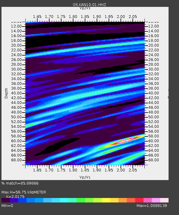
| Estimated Moho Depth: |
59.75 km |
| Estimated Crust Vp/Vs: |
2.02 |
| Assumed Crust Vp: |
6.426 km/s |
| Estimated Crust Vs: |
3.185 km/s |
| Estimated Crust Poisson's Ratio: |
0.34 |
|
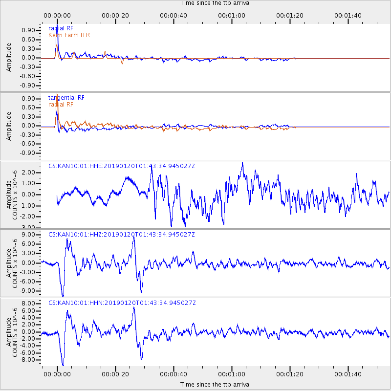
| Radial Match: |
85.89866 % |
| Radial Bump: |
385 |
| Transverse Match: |
77.6312 % |
| Transverse Bump: |
400 |
| SOD ConfigId: |
3260311 |
| Insert Time: |
2019-02-03 01:38:24.807 +0000 |
| GWidth: |
2.5 |
| Max Bumps: |
400 |
| Tol: |
0.001 |
|
Signal To Noise
| Channel | StoN | STA | LTA |
| GS:KAN10:01:HHZ:20190120T01:43:34.945027Z | 20.794893 | 5.67502E-6 | 2.729045E-7 |
| GS:KAN10:01:HHN:20190120T01:43:34.945027Z | 13.664461 | 4.7958565E-6 | 3.5097298E-7 |
| GS:KAN10:01:HHE:20190120T01:43:34.945027Z | 1.7218577 | 1.0046664E-6 | 5.834782E-7 |
| Arrivals |
| Ps | 9.8 SECOND |
| PpPs | 27 SECOND |
| PsPs/PpSs | 37 SECOND |


