You are here: Home > Network List > GS - US Geological Survey Networks Stations List
> Station KAN12 Houston Home > Earthquake Result Viewer
KAN12 Houston Home - Earthquake Result Viewer
| Earthquake location: |
Near Coast Of Central Chile |
| Earthquake latitude/longitude: |
-30.1/-71.4 |
| Earthquake time(UTC): |
2019/01/20 (020) 01:32:51 GMT |
| Earthquake Depth: |
53 km |
| Earthquake Magnitude: |
6.7 mww |
| Earthquake Catalog/Contributor: |
NEIC PDE/us |
|
| Network: |
GS US Geological Survey Networks |
| Station: |
KAN12 Houston Home |
| Lat/Lon: |
37.30 N/98.00 W |
| Elevation: |
426 m |
|
| Distance: |
71.5 deg |
| Az: |
337.901 deg |
| Baz: |
155.862 deg |
| Ray Param: |
0.05418283 |
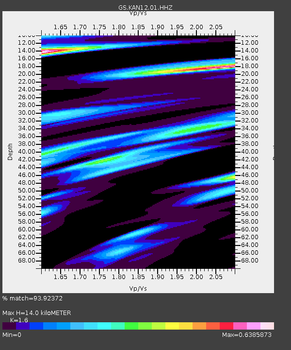
| Estimated Moho Depth: |
14.0 km |
| Estimated Crust Vp/Vs: |
1.60 |
| Assumed Crust Vp: |
6.483 km/s |
| Estimated Crust Vs: |
4.052 km/s |
| Estimated Crust Poisson's Ratio: |
0.18 |
|
| Radial Match: |
93.92372 % |
| Radial Bump: |
334 |
| Transverse Match: |
61.985294 % |
| Transverse Bump: |
400 |
| SOD ConfigId: |
3260311 |
| Insert Time: |
2019-02-03 01:38:27.473 +0000 |
| GWidth: |
2.5 |
| Max Bumps: |
400 |
| Tol: |
0.001 |
|

Signal To Noise
| Channel | StoN | STA | LTA |
| GS:KAN12:01:HHZ:20190120T01:43:35.70998Z | 5.553952 | 8.126774E-6 | 1.4632416E-6 |
| GS:KAN12:01:HHN:20190120T01:43:35.70998Z | 1.7590948 | 3.714963E-6 | 2.1118606E-6 |
| GS:KAN12:01:HHE:20190120T01:43:35.70998Z | 0.9745405 | 1.8030433E-6 | 1.8501473E-6 |
| Arrivals |
| Ps | 1.3 SECOND |
| PpPs | 5.4 SECOND |
| PsPs/PpSs | 6.7 SECOND |


