You are here: Home > Network List > GS - US Geological Survey Networks Stations List
> Station KAN14 Manchester OK Station > Earthquake Result Viewer
KAN14 Manchester OK Station - Earthquake Result Viewer
| Earthquake location: |
Near Coast Of Central Chile |
| Earthquake latitude/longitude: |
-30.1/-71.4 |
| Earthquake time(UTC): |
2019/01/20 (020) 01:32:51 GMT |
| Earthquake Depth: |
53 km |
| Earthquake Magnitude: |
6.7 mww |
| Earthquake Catalog/Contributor: |
NEIC PDE/us |
|
| Network: |
GS US Geological Survey Networks |
| Station: |
KAN14 Manchester OK Station |
| Lat/Lon: |
36.96 N/97.96 W |
| Elevation: |
363 m |
|
| Distance: |
71.2 deg |
| Az: |
337.781 deg |
| Baz: |
155.845 deg |
| Ray Param: |
0.05439732 |
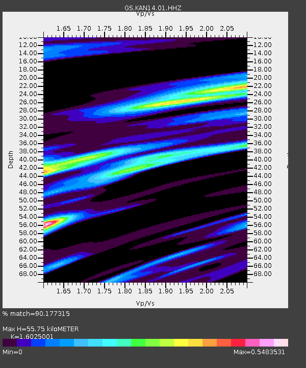
| Estimated Moho Depth: |
55.75 km |
| Estimated Crust Vp/Vs: |
1.60 |
| Assumed Crust Vp: |
6.483 km/s |
| Estimated Crust Vs: |
4.045 km/s |
| Estimated Crust Poisson's Ratio: |
0.18 |
|
| Radial Match: |
90.177315 % |
| Radial Bump: |
225 |
| Transverse Match: |
69.36547 % |
| Transverse Bump: |
400 |
| SOD ConfigId: |
3260311 |
| Insert Time: |
2019-02-03 01:38:30.407 +0000 |
| GWidth: |
2.5 |
| Max Bumps: |
400 |
| Tol: |
0.001 |
|

Signal To Noise
| Channel | StoN | STA | LTA |
| GS:KAN14:01:HHZ:20190120T01:43:33.769978Z | 27.908394 | 6.444252E-6 | 2.3090732E-7 |
| GS:KAN14:01:HHN:20190120T01:43:33.769978Z | 9.911139 | 3.228623E-6 | 3.2575701E-7 |
| GS:KAN14:01:HHE:20190120T01:43:33.769978Z | 6.907898 | 1.4946116E-6 | 2.1636274E-7 |
| Arrivals |
| Ps | 5.4 SECOND |
| PpPs | 21 SECOND |
| PsPs/PpSs | 27 SECOND |


