You are here: Home > Network List > GS - US Geological Survey Networks Stations List
> Station OK029 Liberty Lake, Oklahoma, USA > Earthquake Result Viewer
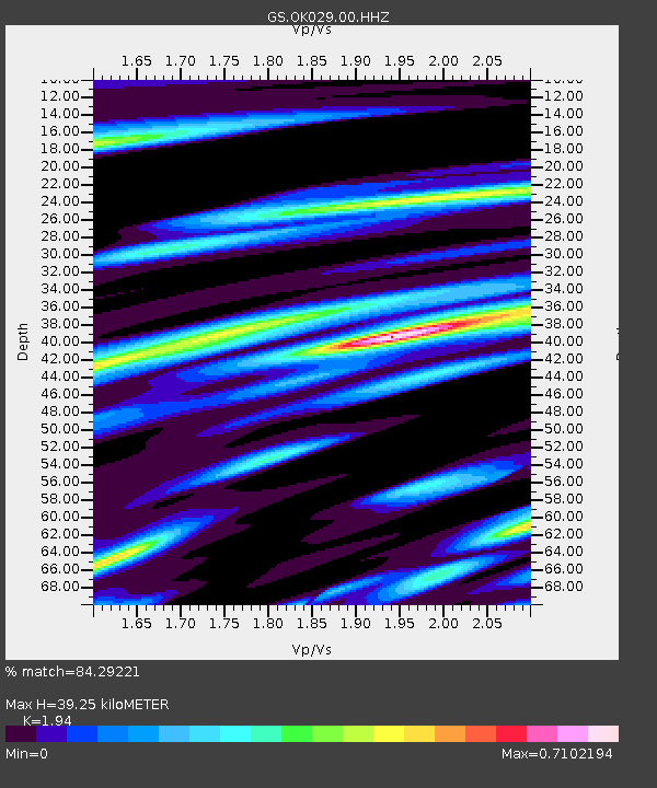
OK029 Liberty Lake, Oklahoma, USA - Earthquake Result Viewer
| Earthquake location: |
Near Coast Of Central Chile |
| Earthquake latitude/longitude: |
-30.1/-71.4 |
| Earthquake time(UTC): |
2019/01/20 (020) 01:32:51 GMT |
| Earthquake Depth: |
53 km |
| Earthquake Magnitude: |
6.7 mww |
| Earthquake Catalog/Contributor: |
NEIC PDE/us |
|
| Network: |
GS US Geological Survey Networks |
| Station: |
OK029 Liberty Lake, Oklahoma, USA |
| Lat/Lon: |
35.80 N/97.45 W |
| Elevation: |
333 m |
|
| Distance: |
69.9 deg |
| Az: |
337.679 deg |
| Baz: |
156.111 deg |
| Ray Param: |
0.055198494 |
| Estimated Moho Depth: |
39.25 km |
| Estimated Crust Vp/Vs: |
1.94 |
| Assumed Crust Vp: |
6.426 km/s |
| Estimated Crust Vs: |
3.312 km/s |
| Estimated Crust Poisson's Ratio: |
0.32 |
|
| Radial Match: |
84.29221 % |
| Radial Bump: |
389 |
| Transverse Match: |
80.71042 % |
| Transverse Bump: |
387 |
| SOD ConfigId: |
3260311 |
| Insert Time: |
2019-02-03 01:38:38.760 +0000 |
| GWidth: |
2.5 |
| Max Bumps: |
400 |
| Tol: |
0.001 |
|

Signal To Noise
| Channel | StoN | STA | LTA |
| GS:OK029:00:HHZ:20190120T01:43:26.329976Z | 17.753105 | 6.4208853E-6 | 3.6167674E-7 |
| GS:OK029:00:HH1:20190120T01:43:26.329976Z | 13.615507 | 2.554829E-6 | 1.8764113E-7 |
| GS:OK029:00:HH2:20190120T01:43:26.329976Z | 2.7843792 | 1.6869192E-6 | 6.058511E-7 |
| Arrivals |
| Ps | 5.9 SECOND |
| PpPs | 17 SECOND |
| PsPs/PpSs | 23 SECOND |


