You are here: Home > Network List > TA - USArray Transportable Network (new EarthScope stations) Stations List
> Station H20A Greybull, WY, USA > Earthquake Result Viewer
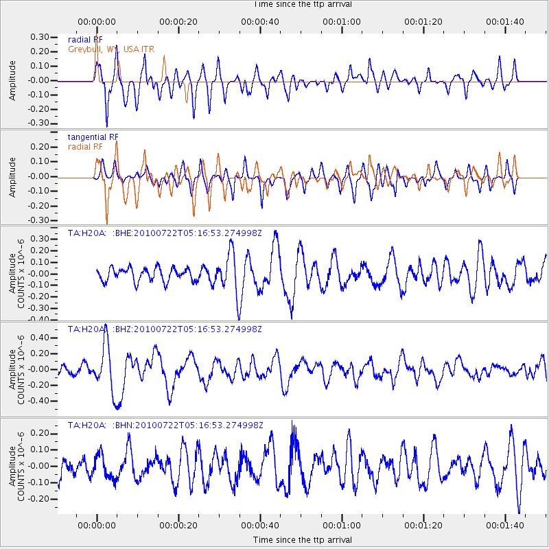
H20A Greybull, WY, USA - Earthquake Result Viewer
*The percent match for this event was below the threshold and hence no stack was calculated.
| Earthquake location: |
Vanuatu Islands |
| Earthquake latitude/longitude: |
-15.1/168.2 |
| Earthquake time(UTC): |
2010/07/22 (203) 05:03:57 GMT |
| Earthquake Depth: |
10 km |
| Earthquake Magnitude: |
6.2 MB, 5.4 MS, 6.1 MW, 5.9 MW |
| Earthquake Catalog/Contributor: |
WHDF/NEIC |
|
| Network: |
TA USArray Transportable Network (new EarthScope stations) |
| Station: |
H20A Greybull, WY, USA |
| Lat/Lon: |
44.49 N/108.00 W |
| Elevation: |
1236 m |
|
| Distance: |
96.1 deg |
| Az: |
45.704 deg |
| Baz: |
254.94 deg |
| Ray Param: |
$rayparam |
*The percent match for this event was below the threshold and hence was not used in the summary stack. |
|
| Radial Match: |
67.48936 % |
| Radial Bump: |
400 |
| Transverse Match: |
51.274166 % |
| Transverse Bump: |
353 |
| SOD ConfigId: |
319893 |
| Insert Time: |
2011-01-05 09:33:11.579 +0000 |
| GWidth: |
2.5 |
| Max Bumps: |
400 |
| Tol: |
0.001 |
|
Signal To Noise
| Channel | StoN | STA | LTA |
| TA:H20A: :BHZ:20100722T05:16:53.274998Z | 4.6060405 | 3.0721594E-7 | 6.669849E-8 |
| TA:H20A: :BHN:20100722T05:16:53.274998Z | 0.9513539 | 7.320357E-8 | 7.694673E-8 |
| TA:H20A: :BHE:20100722T05:16:53.274998Z | 3.2008526 | 1.8145856E-7 | 5.6690695E-8 |
| Arrivals |
| Ps | |
| PpPs | |
| PsPs/PpSs | |


