You are here: Home > Network List > TA - USArray Transportable Network (new EarthScope stations) Stations List
> Station I20A Worland, WY, USA > Earthquake Result Viewer
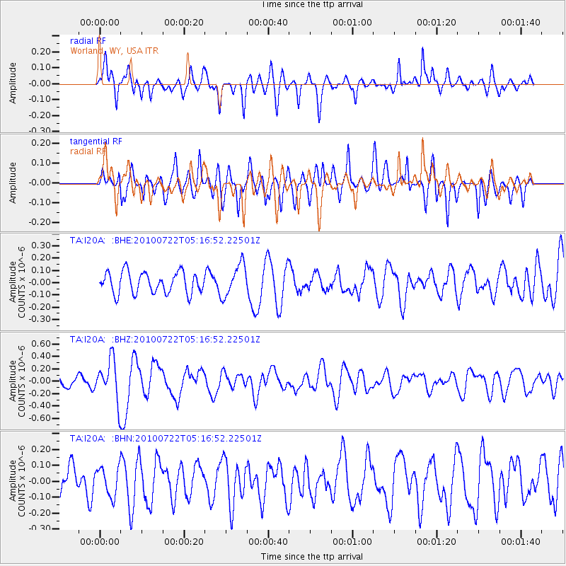
I20A Worland, WY, USA - Earthquake Result Viewer
*The percent match for this event was below the threshold and hence no stack was calculated.
| Earthquake location: |
Vanuatu Islands |
| Earthquake latitude/longitude: |
-15.1/168.2 |
| Earthquake time(UTC): |
2010/07/22 (203) 05:03:57 GMT |
| Earthquake Depth: |
10 km |
| Earthquake Magnitude: |
6.2 MB, 5.4 MS, 6.1 MW, 5.9 MW |
| Earthquake Catalog/Contributor: |
WHDF/NEIC |
|
| Network: |
TA USArray Transportable Network (new EarthScope stations) |
| Station: |
I20A Worland, WY, USA |
| Lat/Lon: |
43.95 N/108.13 W |
| Elevation: |
1342 m |
|
| Distance: |
95.9 deg |
| Az: |
46.2 deg |
| Baz: |
254.798 deg |
| Ray Param: |
$rayparam |
*The percent match for this event was below the threshold and hence was not used in the summary stack. |
|
| Radial Match: |
64.52736 % |
| Radial Bump: |
400 |
| Transverse Match: |
59.25749 % |
| Transverse Bump: |
400 |
| SOD ConfigId: |
319893 |
| Insert Time: |
2011-01-05 09:33:27.517 +0000 |
| GWidth: |
2.5 |
| Max Bumps: |
400 |
| Tol: |
0.001 |
|
Signal To Noise
| Channel | StoN | STA | LTA |
| TA:I20A: :BHZ:20100722T05:16:52.22501Z | 6.192848 | 3.3853834E-7 | 5.4666017E-8 |
| TA:I20A: :BHN:20100722T05:16:52.22501Z | 1.0719938 | 9.1702326E-8 | 8.554371E-8 |
| TA:I20A: :BHE:20100722T05:16:52.22501Z | 1.5306188 | 1.309462E-7 | 8.555115E-8 |
| Arrivals |
| Ps | |
| PpPs | |
| PsPs/PpSs | |


