You are here: Home > Network List > TA - USArray Transportable Network (new EarthScope stations) Stations List
> Station J21A Lysite, WY, USA > Earthquake Result Viewer
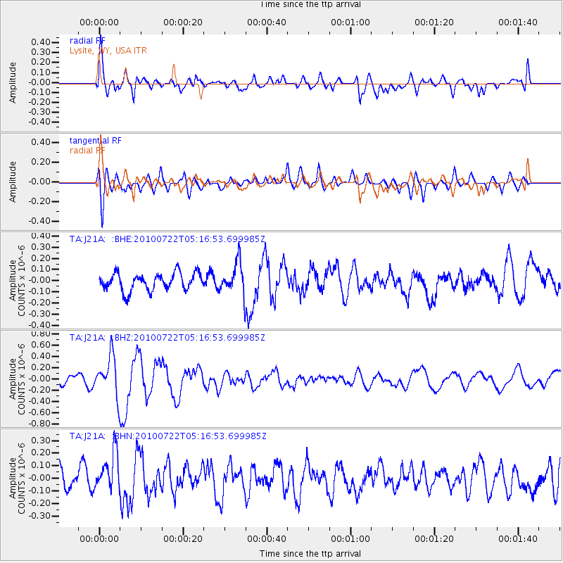
J21A Lysite, WY, USA - Earthquake Result Viewer
*The percent match for this event was below the threshold and hence no stack was calculated.
| Earthquake location: |
Vanuatu Islands |
| Earthquake latitude/longitude: |
-15.1/168.2 |
| Earthquake time(UTC): |
2010/07/22 (203) 05:03:57 GMT |
| Earthquake Depth: |
10 km |
| Earthquake Magnitude: |
6.2 MB, 5.4 MS, 6.1 MW, 5.9 MW |
| Earthquake Catalog/Contributor: |
WHDF/NEIC |
|
| Network: |
TA USArray Transportable Network (new EarthScope stations) |
| Station: |
J21A Lysite, WY, USA |
| Lat/Lon: |
43.35 N/107.45 W |
| Elevation: |
1913 m |
|
| Distance: |
96.2 deg |
| Az: |
46.916 deg |
| Baz: |
255.192 deg |
| Ray Param: |
$rayparam |
*The percent match for this event was below the threshold and hence was not used in the summary stack. |
|
| Radial Match: |
68.35747 % |
| Radial Bump: |
400 |
| Transverse Match: |
62.200996 % |
| Transverse Bump: |
400 |
| SOD ConfigId: |
319893 |
| Insert Time: |
2011-01-05 09:33:42.185 +0000 |
| GWidth: |
2.5 |
| Max Bumps: |
400 |
| Tol: |
0.001 |
|
Signal To Noise
| Channel | StoN | STA | LTA |
| TA:J21A: :BHZ:20100722T05:16:53.699985Z | 6.0916157 | 3.6221732E-7 | 5.9461616E-8 |
| TA:J21A: :BHN:20100722T05:16:53.699985Z | 2.0620048 | 1.6950584E-7 | 8.220438E-8 |
| TA:J21A: :BHE:20100722T05:16:53.699985Z | 1.8940303 | 1.472342E-7 | 7.7735926E-8 |
| Arrivals |
| Ps | |
| PpPs | |
| PsPs/PpSs | |


