You are here: Home > Network List > TA - USArray Transportable Network (new EarthScope stations) Stations List
> Station I22A 9 Mile Ranch, Kaycee, WY, USA > Earthquake Result Viewer
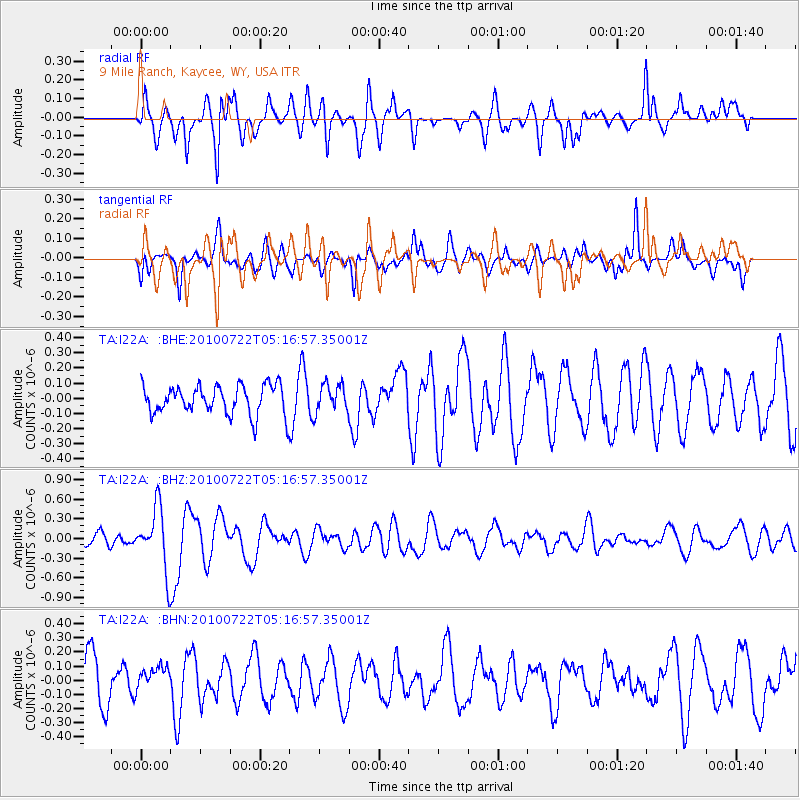
I22A 9 Mile Ranch, Kaycee, WY, USA - Earthquake Result Viewer
*The percent match for this event was below the threshold and hence no stack was calculated.
| Earthquake location: |
Vanuatu Islands |
| Earthquake latitude/longitude: |
-15.1/168.2 |
| Earthquake time(UTC): |
2010/07/22 (203) 05:03:57 GMT |
| Earthquake Depth: |
10 km |
| Earthquake Magnitude: |
6.2 MB, 5.4 MS, 6.1 MW, 5.9 MW |
| Earthquake Catalog/Contributor: |
WHDF/NEIC |
|
| Network: |
TA USArray Transportable Network (new EarthScope stations) |
| Station: |
I22A 9 Mile Ranch, Kaycee, WY, USA |
| Lat/Lon: |
43.89 N/106.48 W |
| Elevation: |
1430 m |
|
| Distance: |
97.1 deg |
| Az: |
46.559 deg |
| Baz: |
255.894 deg |
| Ray Param: |
$rayparam |
*The percent match for this event was below the threshold and hence was not used in the summary stack. |
|
| Radial Match: |
71.40056 % |
| Radial Bump: |
383 |
| Transverse Match: |
58.6404 % |
| Transverse Bump: |
400 |
| SOD ConfigId: |
319893 |
| Insert Time: |
2011-01-05 09:34:42.781 +0000 |
| GWidth: |
2.5 |
| Max Bumps: |
400 |
| Tol: |
0.001 |
|
Signal To Noise
| Channel | StoN | STA | LTA |
| TA:I22A: :BHZ:20100722T05:16:57.35001Z | 5.7490387 | 4.6499753E-7 | 8.088266E-8 |
| TA:I22A: :BHN:20100722T05:16:57.35001Z | 0.54475784 | 8.502639E-8 | 1.5608107E-7 |
| TA:I22A: :BHE:20100722T05:16:57.35001Z | 0.9500244 | 9.152315E-8 | 9.633767E-8 |
| Arrivals |
| Ps | |
| PpPs | |
| PsPs/PpSs | |


