You are here: Home > Network List > IU - Global Seismograph Network (GSN - IRIS/USGS) Stations List
> Station PMSA Palmer Station, Antarctica > Earthquake Result Viewer
PMSA Palmer Station, Antarctica - Earthquake Result Viewer
| Earthquake location: |
Near Coast Of Central Chile |
| Earthquake latitude/longitude: |
-30.1/-71.4 |
| Earthquake time(UTC): |
2019/01/20 (020) 01:32:51 GMT |
| Earthquake Depth: |
53 km |
| Earthquake Magnitude: |
6.7 mww |
| Earthquake Catalog/Contributor: |
NEIC PDE/us |
|
| Network: |
IU Global Seismograph Network (GSN - IRIS/USGS) |
| Station: |
PMSA Palmer Station, Antarctica |
| Lat/Lon: |
64.77 S/64.05 W |
| Elevation: |
40 m |
|
| Distance: |
35.0 deg |
| Az: |
174.501 deg |
| Baz: |
348.822 deg |
| Ray Param: |
0.07730525 |
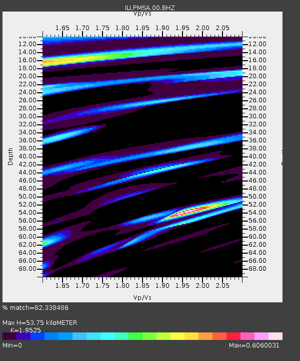
| Estimated Moho Depth: |
53.75 km |
| Estimated Crust Vp/Vs: |
1.95 |
| Assumed Crust Vp: |
6.183 km/s |
| Estimated Crust Vs: |
3.167 km/s |
| Estimated Crust Poisson's Ratio: |
0.32 |
|
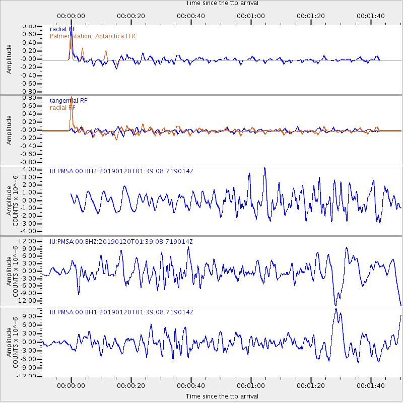
| Radial Match: |
82.338486 % |
| Radial Bump: |
400 |
| Transverse Match: |
62.956142 % |
| Transverse Bump: |
400 |
| SOD ConfigId: |
3260311 |
| Insert Time: |
2019-02-03 01:39:13.511 +0000 |
| GWidth: |
2.5 |
| Max Bumps: |
400 |
| Tol: |
0.001 |
|
Signal To Noise
| Channel | StoN | STA | LTA |
| IU:PMSA:00:BHZ:20190120T01:39:08.719014Z | 3.469276 | 3.4605318E-6 | 9.974796E-7 |
| IU:PMSA:00:BH1:20190120T01:39:08.719014Z | 2.3658624 | 1.7928147E-6 | 7.5778485E-7 |
| IU:PMSA:00:BH2:20190120T01:39:08.719014Z | 0.7393492 | 6.787004E-7 | 9.1797006E-7 |
| Arrivals |
| Ps | 8.8 SECOND |
| PpPs | 24 SECOND |
| PsPs/PpSs | 33 SECOND |


