You are here: Home > Network List > AV - Alaska Volcano Observatory Stations List
> Station SPCL Chakachamna Lake, Mount Spurr, Alaska > Earthquake Result Viewer
SPCL Chakachamna Lake, Mount Spurr, Alaska - Earthquake Result Viewer
| Earthquake location: |
Southeast Of Honshu, Japan |
| Earthquake latitude/longitude: |
30.0/139.9 |
| Earthquake time(UTC): |
2023/10/05 (278) 01:59:58 GMT |
| Earthquake Depth: |
10 km |
| Earthquake Magnitude: |
6.1 mww |
| Earthquake Catalog/Contributor: |
NEIC PDE/us |
|
| Network: |
AV Alaska Volcano Observatory |
| Station: |
SPCL Chakachamna Lake, Mount Spurr, Alaska |
| Lat/Lon: |
61.20 N/152.34 W |
| Elevation: |
1274 m |
|
| Distance: |
53.6 deg |
| Az: |
33.856 deg |
| Baz: |
266.628 deg |
| Ray Param: |
0.06603615 |
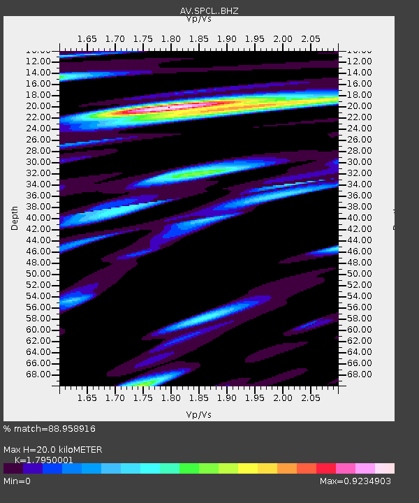
| Estimated Moho Depth: |
20.0 km |
| Estimated Crust Vp/Vs: |
1.80 |
| Assumed Crust Vp: |
6.566 km/s |
| Estimated Crust Vs: |
3.658 km/s |
| Estimated Crust Poisson's Ratio: |
0.27 |
|
| Radial Match: |
88.958916 % |
| Radial Bump: |
400 |
| Transverse Match: |
72.5991 % |
| Transverse Bump: |
400 |
| SOD ConfigId: |
31937991 |
| Insert Time: |
2023-10-19 02:08:57.668 +0000 |
| GWidth: |
2.5 |
| Max Bumps: |
400 |
| Tol: |
0.001 |
|

Signal To Noise
| Channel | StoN | STA | LTA |
| AV:SPCL: :BHZ:20231005T02:08:48.800018Z | 5.783196 | 1.0672368E-6 | 1.8454101E-7 |
| AV:SPCL: :BHN:20231005T02:08:48.800018Z | 0.9848366 | 2.7926185E-7 | 2.8356163E-7 |
| AV:SPCL: :BHE:20231005T02:08:48.800018Z | 2.4114368 | 4.8011566E-7 | 1.9909943E-7 |
| Arrivals |
| Ps | 2.6 SECOND |
| PpPs | 8.1 SECOND |
| PsPs/PpSs | 11 SECOND |


