You are here: Home > Network List > TA - USArray Transportable Network (new EarthScope stations) Stations List
> Station R26A Arlington, CO, USA > Earthquake Result Viewer
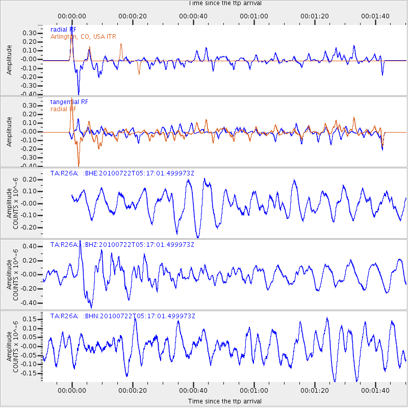
R26A Arlington, CO, USA - Earthquake Result Viewer
*The percent match for this event was below the threshold and hence no stack was calculated.
| Earthquake location: |
Vanuatu Islands |
| Earthquake latitude/longitude: |
-15.1/168.2 |
| Earthquake time(UTC): |
2010/07/22 (203) 05:03:57 GMT |
| Earthquake Depth: |
10 km |
| Earthquake Magnitude: |
6.2 MB, 5.4 MS, 6.1 MW, 5.9 MW |
| Earthquake Catalog/Contributor: |
WHDF/NEIC |
|
| Network: |
TA USArray Transportable Network (new EarthScope stations) |
| Station: |
R26A Arlington, CO, USA |
| Lat/Lon: |
38.30 N/103.45 W |
| Elevation: |
1304 m |
|
| Distance: |
98.0 deg |
| Az: |
52.577 deg |
| Baz: |
257.098 deg |
| Ray Param: |
$rayparam |
*The percent match for this event was below the threshold and hence was not used in the summary stack. |
|
| Radial Match: |
70.81689 % |
| Radial Bump: |
370 |
| Transverse Match: |
52.648937 % |
| Transverse Bump: |
369 |
| SOD ConfigId: |
319893 |
| Insert Time: |
2011-01-05 09:36:08.227 +0000 |
| GWidth: |
2.5 |
| Max Bumps: |
400 |
| Tol: |
0.001 |
|
Signal To Noise
| Channel | StoN | STA | LTA |
| TA:R26A: :BHZ:20100722T05:17:01.499973Z | 2.3387544 | 2.0525225E-7 | 8.776135E-8 |
| TA:R26A: :BHN:20100722T05:17:01.499973Z | 0.9350353 | 5.7699413E-8 | 6.170828E-8 |
| TA:R26A: :BHE:20100722T05:17:01.499973Z | 1.7243551 | 1.10159476E-7 | 6.388445E-8 |
| Arrivals |
| Ps | |
| PpPs | |
| PsPs/PpSs | |


