You are here: Home > Network List > IU - Global Seismograph Network (GSN - IRIS/USGS) Stations List
> Station SLBS Sierra la Laguna Baja California Sur, Mexico > Earthquake Result Viewer
SLBS Sierra la Laguna Baja California Sur, Mexico - Earthquake Result Viewer
| Earthquake location: |
Near Coast Of Central Chile |
| Earthquake latitude/longitude: |
-30.1/-71.4 |
| Earthquake time(UTC): |
2019/01/20 (020) 01:32:51 GMT |
| Earthquake Depth: |
53 km |
| Earthquake Magnitude: |
6.7 mww |
| Earthquake Catalog/Contributor: |
NEIC PDE/us |
|
| Network: |
IU Global Seismograph Network (GSN - IRIS/USGS) |
| Station: |
SLBS Sierra la Laguna Baja California Sur, Mexico |
| Lat/Lon: |
23.69 N/109.94 W |
| Elevation: |
825 m |
|
| Distance: |
65.0 deg |
| Az: |
320.953 deg |
| Baz: |
143.44 deg |
| Ray Param: |
0.05844156 |
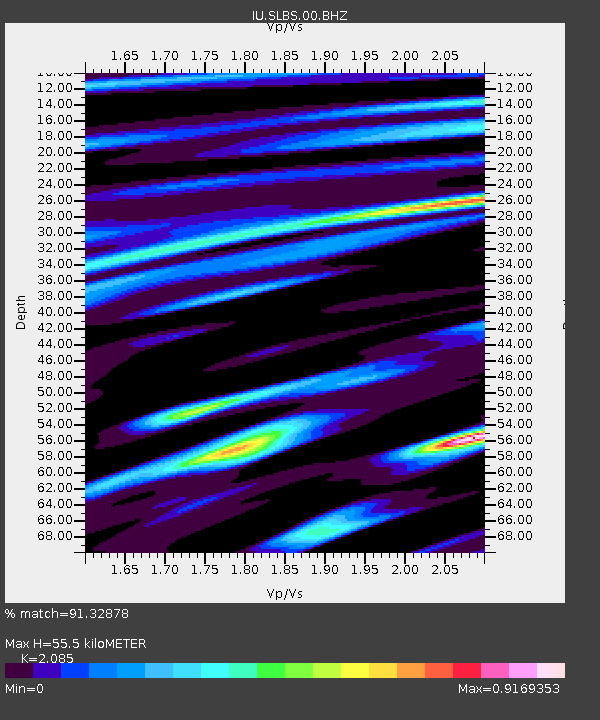
| Estimated Moho Depth: |
55.5 km |
| Estimated Crust Vp/Vs: |
2.09 |
| Assumed Crust Vp: |
6.183 km/s |
| Estimated Crust Vs: |
2.965 km/s |
| Estimated Crust Poisson's Ratio: |
0.35 |
|
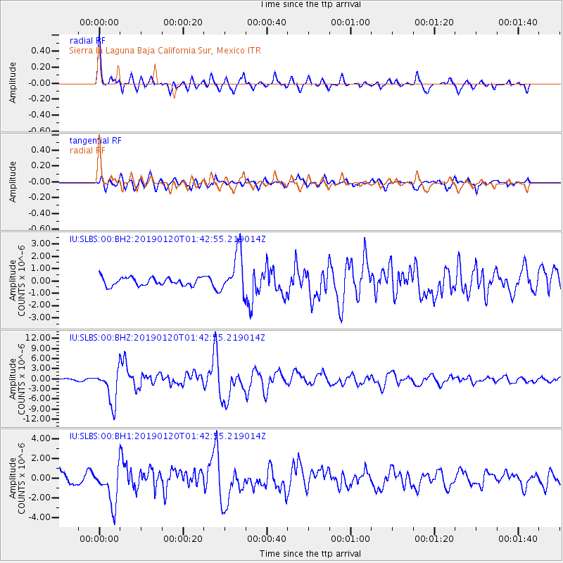
| Radial Match: |
91.32878 % |
| Radial Bump: |
400 |
| Transverse Match: |
85.91829 % |
| Transverse Bump: |
400 |
| SOD ConfigId: |
3260311 |
| Insert Time: |
2019-02-03 01:39:25.601 +0000 |
| GWidth: |
2.5 |
| Max Bumps: |
400 |
| Tol: |
0.001 |
|
Signal To Noise
| Channel | StoN | STA | LTA |
| IU:SLBS:00:BHZ:20190120T01:42:55.219014Z | 10.080125 | 5.1591855E-6 | 5.1181763E-7 |
| IU:SLBS:00:BH1:20190120T01:42:55.219014Z | 3.272256 | 1.9408828E-6 | 5.93133E-7 |
| IU:SLBS:00:BH2:20190120T01:42:55.219014Z | 5.4445243 | 1.7272204E-6 | 3.172399E-7 |
| Arrivals |
| Ps | 10 SECOND |
| PpPs | 27 SECOND |
| PsPs/PpSs | 37 SECOND |


