You are here: Home > Network List > C0 - Colorado Geological Survey Seismic Network Stations List
> Station SPVA SPVA > Earthquake Result Viewer
SPVA SPVA - Earthquake Result Viewer
| Earthquake location: |
Southeast Of Honshu, Japan |
| Earthquake latitude/longitude: |
30.0/139.9 |
| Earthquake time(UTC): |
2023/10/05 (278) 01:59:58 GMT |
| Earthquake Depth: |
10 km |
| Earthquake Magnitude: |
6.1 mww |
| Earthquake Catalog/Contributor: |
NEIC PDE/us |
|
| Network: |
C0 Colorado Geological Survey Seismic Network |
| Station: |
SPVA SPVA |
| Lat/Lon: |
39.47 N/107.22 W |
| Elevation: |
2176 m |
|
| Distance: |
86.9 deg |
| Az: |
45.596 deg |
| Baz: |
306.773 deg |
| Ray Param: |
0.043713756 |
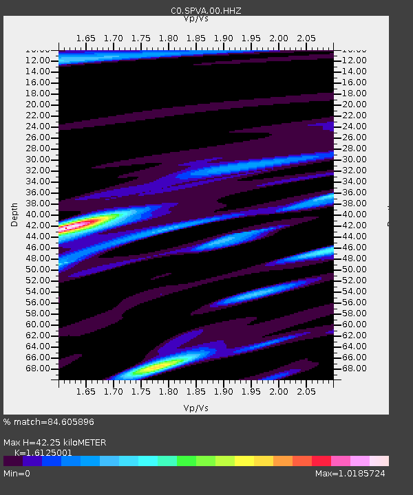
| Estimated Moho Depth: |
42.25 km |
| Estimated Crust Vp/Vs: |
1.61 |
| Assumed Crust Vp: |
6.306 km/s |
| Estimated Crust Vs: |
3.911 km/s |
| Estimated Crust Poisson's Ratio: |
0.19 |
|
| Radial Match: |
84.605896 % |
| Radial Bump: |
400 |
| Transverse Match: |
69.401054 % |
| Transverse Bump: |
400 |
| SOD ConfigId: |
31937991 |
| Insert Time: |
2023-10-19 02:10:43.639 +0000 |
| GWidth: |
2.5 |
| Max Bumps: |
400 |
| Tol: |
0.001 |
|

Signal To Noise
| Channel | StoN | STA | LTA |
| C0:SPVA:00:HHZ:20231005T02:12:12.324005Z | 2.5421953 | 3.2071443E-7 | 1.2615648E-7 |
| C0:SPVA:00:HHN:20231005T02:12:12.324005Z | 1.2016537 | 1.0367613E-7 | 8.627788E-8 |
| C0:SPVA:00:HHE:20231005T02:12:12.324005Z | 0.94789845 | 1.2075523E-7 | 1.2739258E-7 |
| Arrivals |
| Ps | 4.2 SECOND |
| PpPs | 17 SECOND |
| PsPs/PpSs | 21 SECOND |


