You are here: Home > Network List > TA - USArray Transportable Network (new EarthScope stations) Stations List
> Station 430A Baggett Ranch, Ozona, TX, USA > Earthquake Result Viewer
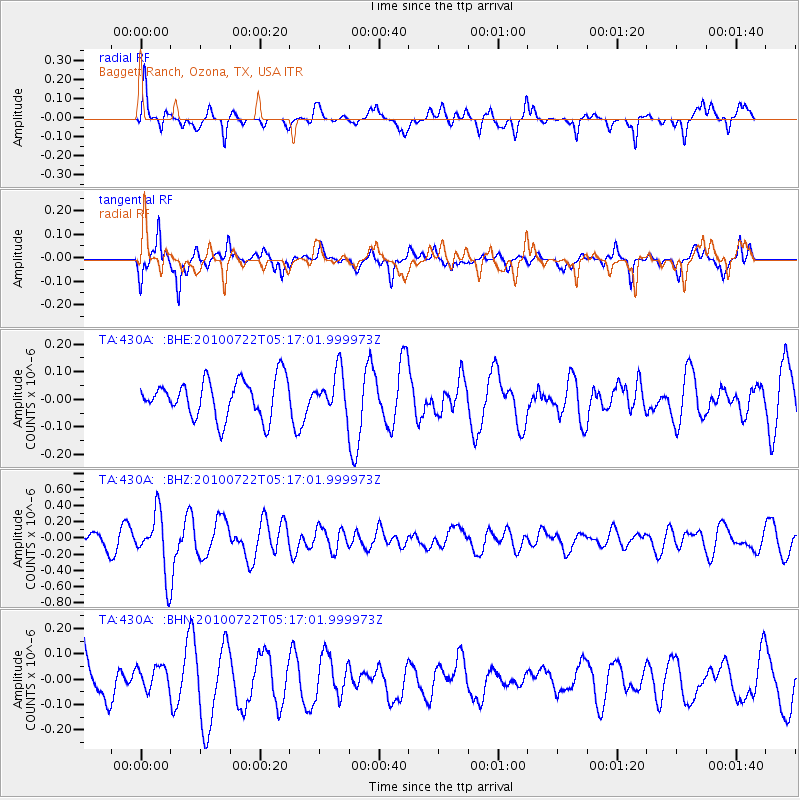
430A Baggett Ranch, Ozona, TX, USA - Earthquake Result Viewer
*The percent match for this event was below the threshold and hence no stack was calculated.
| Earthquake location: |
Vanuatu Islands |
| Earthquake latitude/longitude: |
-15.1/168.2 |
| Earthquake time(UTC): |
2010/07/22 (203) 05:03:57 GMT |
| Earthquake Depth: |
10 km |
| Earthquake Magnitude: |
6.2 MB, 5.4 MS, 6.1 MW, 5.9 MW |
| Earthquake Catalog/Contributor: |
WHDF/NEIC |
|
| Network: |
TA USArray Transportable Network (new EarthScope stations) |
| Station: |
430A Baggett Ranch, Ozona, TX, USA |
| Lat/Lon: |
30.79 N/101.24 W |
| Elevation: |
768 m |
|
| Distance: |
98.1 deg |
| Az: |
60.367 deg |
| Baz: |
257.257 deg |
| Ray Param: |
$rayparam |
*The percent match for this event was below the threshold and hence was not used in the summary stack. |
|
| Radial Match: |
60.89216 % |
| Radial Bump: |
359 |
| Transverse Match: |
69.47441 % |
| Transverse Bump: |
260 |
| SOD ConfigId: |
319893 |
| Insert Time: |
2011-01-05 09:38:14.229 +0000 |
| GWidth: |
2.5 |
| Max Bumps: |
400 |
| Tol: |
0.001 |
|
Signal To Noise
| Channel | StoN | STA | LTA |
| TA:430A: :BHZ:20100722T05:17:01.999973Z | 3.0649247 | 3.6810508E-7 | 1.2010248E-7 |
| TA:430A: :BHN:20100722T05:17:01.999973Z | 0.58659244 | 4.5635996E-8 | 7.7798475E-8 |
| TA:430A: :BHE:20100722T05:17:01.999973Z | 1.0709537 | 7.335822E-8 | 6.849804E-8 |
| Arrivals |
| Ps | |
| PpPs | |
| PsPs/PpSs | |


