You are here: Home > Network List > TA - USArray Transportable Network (new EarthScope stations) Stations List
> Station I05D Terrebonne, OR, USA > Earthquake Result Viewer
I05D Terrebonne, OR, USA - Earthquake Result Viewer
| Earthquake location: |
Vanuatu Islands |
| Earthquake latitude/longitude: |
-15.1/168.2 |
| Earthquake time(UTC): |
2010/07/22 (203) 05:03:57 GMT |
| Earthquake Depth: |
10 km |
| Earthquake Magnitude: |
6.2 MB, 5.4 MS, 6.1 MW, 5.9 MW |
| Earthquake Catalog/Contributor: |
WHDF/NEIC |
|
| Network: |
TA USArray Transportable Network (new EarthScope stations) |
| Station: |
I05D Terrebonne, OR, USA |
| Lat/Lon: |
44.34 N/121.34 W |
| Elevation: |
1546 m |
|
| Distance: |
87.1 deg |
| Az: |
42.628 deg |
| Baz: |
245.702 deg |
| Ray Param: |
0.0435648 |
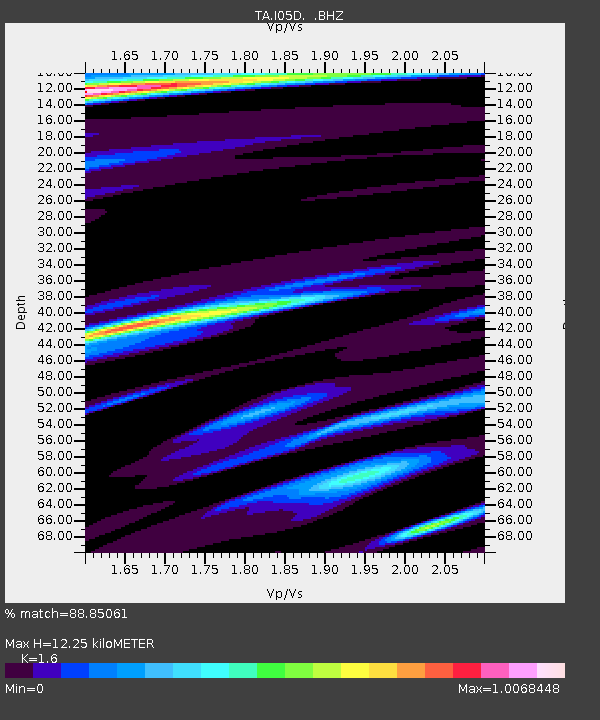
| Estimated Moho Depth: |
12.25 km |
| Estimated Crust Vp/Vs: |
1.60 |
| Assumed Crust Vp: |
6.597 km/s |
| Estimated Crust Vs: |
4.123 km/s |
| Estimated Crust Poisson's Ratio: |
0.18 |
|
| Radial Match: |
88.85061 % |
| Radial Bump: |
334 |
| Transverse Match: |
72.110504 % |
| Transverse Bump: |
329 |
| SOD ConfigId: |
319893 |
| Insert Time: |
2011-01-05 09:39:12.449 +0000 |
| GWidth: |
2.5 |
| Max Bumps: |
400 |
| Tol: |
0.001 |
|

Signal To Noise
| Channel | StoN | STA | LTA |
| TA:I05D: :BHZ:20100722T05:16:11.449985Z | 12.150674 | 2.2164252E-6 | 1.8241171E-7 |
| TA:I05D: :BHN:20100722T05:16:11.449985Z | 1.4146982 | 3.162701E-7 | 2.2356012E-7 |
| TA:I05D: :BHE:20100722T05:16:11.449985Z | 1.7453909 | 3.4986022E-7 | 2.0044806E-7 |
| Arrivals |
| Ps | 1.1 SECOND |
| PpPs | 4.7 SECOND |
| PsPs/PpSs | 5.8 SECOND |


