You are here: Home > Network List > TA - USArray Transportable Network (new EarthScope stations) Stations List
> Station G05D Wamic, OR, USA > Earthquake Result Viewer
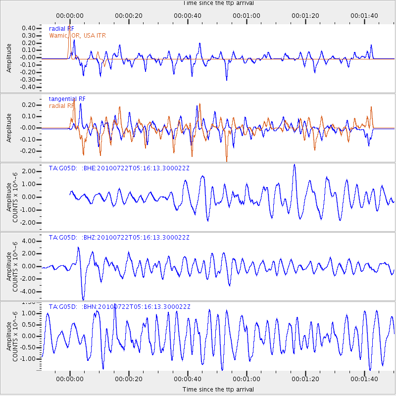
G05D Wamic, OR, USA - Earthquake Result Viewer
*The percent match for this event was below the threshold and hence no stack was calculated.
| Earthquake location: |
Vanuatu Islands |
| Earthquake latitude/longitude: |
-15.1/168.2 |
| Earthquake time(UTC): |
2010/07/22 (203) 05:03:57 GMT |
| Earthquake Depth: |
10 km |
| Earthquake Magnitude: |
6.2 MB, 5.4 MS, 6.1 MW, 5.9 MW |
| Earthquake Catalog/Contributor: |
WHDF/NEIC |
|
| Network: |
TA USArray Transportable Network (new EarthScope stations) |
| Station: |
G05D Wamic, OR, USA |
| Lat/Lon: |
45.24 N/121.32 W |
| Elevation: |
592 m |
|
| Distance: |
87.5 deg |
| Az: |
41.811 deg |
| Baz: |
245.68 deg |
| Ray Param: |
$rayparam |
*The percent match for this event was below the threshold and hence was not used in the summary stack. |
|
| Radial Match: |
76.30296 % |
| Radial Bump: |
354 |
| Transverse Match: |
57.006477 % |
| Transverse Bump: |
362 |
| SOD ConfigId: |
319893 |
| Insert Time: |
2011-01-05 09:39:27.716 +0000 |
| GWidth: |
2.5 |
| Max Bumps: |
400 |
| Tol: |
0.001 |
|
Signal To Noise
| Channel | StoN | STA | LTA |
| TA:G05D: :BHZ:20100722T05:16:13.300022Z | 7.1931744 | 2.197272E-6 | 3.0546624E-7 |
| TA:G05D: :BHN:20100722T05:16:13.300022Z | 0.74671733 | 3.571229E-7 | 4.7825716E-7 |
| TA:G05D: :BHE:20100722T05:16:13.300022Z | 0.64772445 | 1.9336882E-7 | 2.985356E-7 |
| Arrivals |
| Ps | |
| PpPs | |
| PsPs/PpSs | |


