You are here: Home > Network List > MM - Myanmar National Seismic Network Stations List
> Station NGU Ngaung U, Myanmar > Earthquake Result Viewer
NGU Ngaung U, Myanmar - Earthquake Result Viewer
| Earthquake location: |
Southeast Of Honshu, Japan |
| Earthquake latitude/longitude: |
30.0/139.9 |
| Earthquake time(UTC): |
2023/10/05 (278) 01:59:58 GMT |
| Earthquake Depth: |
10 km |
| Earthquake Magnitude: |
6.1 mww |
| Earthquake Catalog/Contributor: |
NEIC PDE/us |
|
| Network: |
MM Myanmar National Seismic Network |
| Station: |
NGU Ngaung U, Myanmar |
| Lat/Lon: |
21.21 N/94.92 E |
| Elevation: |
70 m |
|
| Distance: |
41.3 deg |
| Az: |
268.648 deg |
| Baz: |
68.402 deg |
| Ray Param: |
0.073864706 |
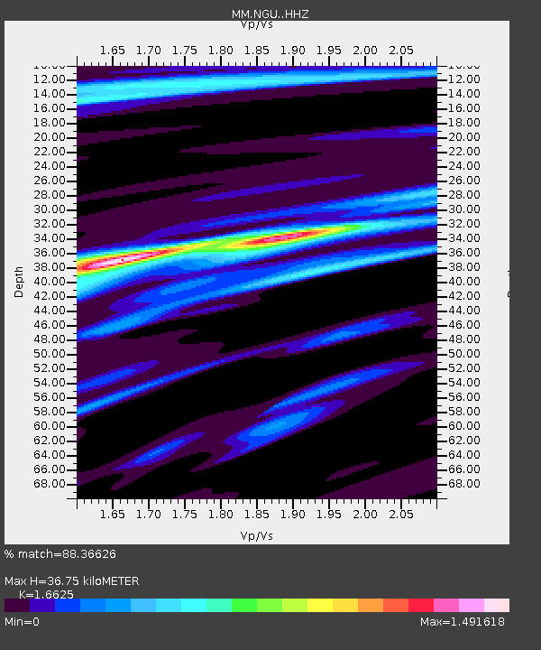
| Estimated Moho Depth: |
36.75 km |
| Estimated Crust Vp/Vs: |
1.66 |
| Assumed Crust Vp: |
6.036 km/s |
| Estimated Crust Vs: |
3.631 km/s |
| Estimated Crust Poisson's Ratio: |
0.22 |
|
| Radial Match: |
88.36626 % |
| Radial Bump: |
381 |
| Transverse Match: |
65.80046 % |
| Transverse Bump: |
400 |
| SOD ConfigId: |
31937991 |
| Insert Time: |
2023-10-19 02:22:01.504 +0000 |
| GWidth: |
2.5 |
| Max Bumps: |
400 |
| Tol: |
0.001 |
|

Signal To Noise
| Channel | StoN | STA | LTA |
| MM:NGU: :HHZ:20231005T02:07:13.839996Z | 4.4273267 | 1.6328377E-6 | 3.688089E-7 |
| MM:NGU: :HHN:20231005T02:07:13.839996Z | 0.94824666 | 3.0789087E-7 | 3.2469492E-7 |
| MM:NGU: :HHE:20231005T02:07:13.839996Z | 1.2050444 | 5.308911E-7 | 4.4055733E-7 |
| Arrivals |
| Ps | 4.3 SECOND |
| PpPs | 15 SECOND |
| PsPs/PpSs | 20 SECOND |


