You are here: Home > Network List > NM - Cooperative New Madrid Seismic Network Stations List
> Station HENM Henderson Mound,MO > Earthquake Result Viewer
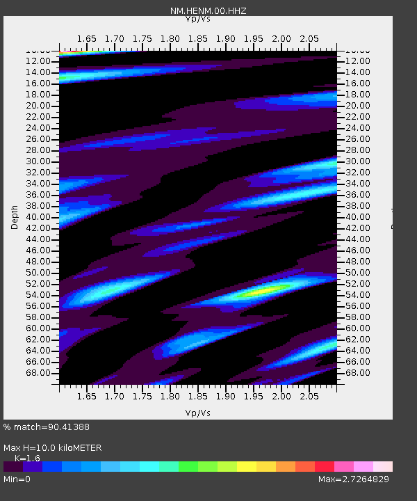
HENM Henderson Mound,MO - Earthquake Result Viewer
| Earthquake location: |
Near Coast Of Central Chile |
| Earthquake latitude/longitude: |
-30.1/-71.4 |
| Earthquake time(UTC): |
2019/01/20 (020) 01:32:51 GMT |
| Earthquake Depth: |
53 km |
| Earthquake Magnitude: |
6.7 mww |
| Earthquake Catalog/Contributor: |
NEIC PDE/us |
|
| Network: |
NM Cooperative New Madrid Seismic Network |
| Station: |
HENM Henderson Mound,MO |
| Lat/Lon: |
36.72 N/89.47 W |
| Elevation: |
88 m |
|
| Distance: |
68.6 deg |
| Az: |
344.487 deg |
| Baz: |
163.23 deg |
| Ray Param: |
0.056111295 |
| Estimated Moho Depth: |
10.0 km |
| Estimated Crust Vp/Vs: |
1.60 |
| Assumed Crust Vp: |
6.444 km/s |
| Estimated Crust Vs: |
4.027 km/s |
| Estimated Crust Poisson's Ratio: |
0.18 |
|
| Radial Match: |
90.41388 % |
| Radial Bump: |
400 |
| Transverse Match: |
90.19634 % |
| Transverse Bump: |
400 |
| SOD ConfigId: |
3260311 |
| Insert Time: |
2019-02-03 01:40:31.085 +0000 |
| GWidth: |
2.5 |
| Max Bumps: |
400 |
| Tol: |
0.001 |
|

Signal To Noise
| Channel | StoN | STA | LTA |
| NM:HENM:00:HHZ:20190120T01:43:17.800007Z | 27.100296 | 1.4109141E-5 | 5.206268E-7 |
| NM:HENM:00:HHN:20190120T01:43:17.800007Z | 8.491369 | 9.123771E-6 | 1.0744758E-6 |
| NM:HENM:00:HHE:20190120T01:43:17.800007Z | 7.096869 | 6.9744174E-6 | 9.827456E-7 |
| Arrivals |
| Ps | 1.0 SECOND |
| PpPs | 3.9 SECOND |
| PsPs/PpSs | 4.8 SECOND |


