You are here: Home > Network List > UW - Pacific Northwest Regional Seismic Network Stations List
> Station LEBA Lebam, WA, USA > Earthquake Result Viewer
LEBA Lebam, WA, USA - Earthquake Result Viewer
| Earthquake location: |
Vanuatu Islands |
| Earthquake latitude/longitude: |
-15.1/168.2 |
| Earthquake time(UTC): |
2010/07/22 (203) 05:03:57 GMT |
| Earthquake Depth: |
10 km |
| Earthquake Magnitude: |
6.2 MB, 5.4 MS, 6.1 MW, 5.9 MW |
| Earthquake Catalog/Contributor: |
WHDF/NEIC |
|
| Network: |
UW Pacific Northwest Regional Seismic Network |
| Station: |
LEBA Lebam, WA, USA |
| Lat/Lon: |
46.55 N/123.56 W |
| Elevation: |
73 m |
|
| Distance: |
86.6 deg |
| Az: |
39.961 deg |
| Baz: |
243.977 deg |
| Ray Param: |
0.04391568 |
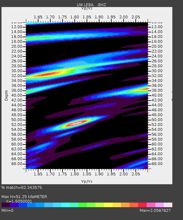
| Estimated Moho Depth: |
51.25 km |
| Estimated Crust Vp/Vs: |
1.81 |
| Assumed Crust Vp: |
6.566 km/s |
| Estimated Crust Vs: |
3.638 km/s |
| Estimated Crust Poisson's Ratio: |
0.28 |
|
| Radial Match: |
82.343575 % |
| Radial Bump: |
400 |
| Transverse Match: |
77.59239 % |
| Transverse Bump: |
400 |
| SOD ConfigId: |
319893 |
| Insert Time: |
2011-01-05 09:46:28.363 +0000 |
| GWidth: |
2.5 |
| Max Bumps: |
400 |
| Tol: |
0.001 |
|

Signal To Noise
| Channel | StoN | STA | LTA |
| UW:LEBA: :BHZ:20100722T05:16:09.124973Z | 6.591121 | 1.8592629E-6 | 2.8208598E-7 |
| UW:LEBA: :BHN:20100722T05:16:09.124973Z | 0.59098625 | 1.313725E-7 | 2.2229368E-7 |
| UW:LEBA: :BHE:20100722T05:16:09.124973Z | 1.6317475 | 5.3126655E-7 | 3.2558134E-7 |
| Arrivals |
| Ps | 6.4 SECOND |
| PpPs | 21 SECOND |
| PsPs/PpSs | 28 SECOND |


