You are here: Home > Network List > NM - Cooperative New Madrid Seismic Network Stations List
> Station SIUC Carbondale, IL > Earthquake Result Viewer
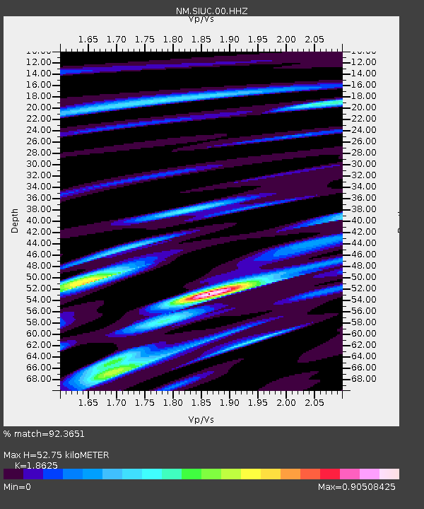
SIUC Carbondale, IL - Earthquake Result Viewer
| Earthquake location: |
Near Coast Of Central Chile |
| Earthquake latitude/longitude: |
-30.1/-71.4 |
| Earthquake time(UTC): |
2019/01/20 (020) 01:32:51 GMT |
| Earthquake Depth: |
53 km |
| Earthquake Magnitude: |
6.7 mww |
| Earthquake Catalog/Contributor: |
NEIC PDE/us |
|
| Network: |
NM Cooperative New Madrid Seismic Network |
| Station: |
SIUC Carbondale, IL |
| Lat/Lon: |
37.71 N/89.22 W |
| Elevation: |
120 m |
|
| Distance: |
69.5 deg |
| Az: |
345.001 deg |
| Baz: |
163.568 deg |
| Ray Param: |
0.055521548 |
| Estimated Moho Depth: |
52.75 km |
| Estimated Crust Vp/Vs: |
1.86 |
| Assumed Crust Vp: |
6.444 km/s |
| Estimated Crust Vs: |
3.46 km/s |
| Estimated Crust Poisson's Ratio: |
0.30 |
|
| Radial Match: |
92.3651 % |
| Radial Bump: |
400 |
| Transverse Match: |
84.8957 % |
| Transverse Bump: |
400 |
| SOD ConfigId: |
3260311 |
| Insert Time: |
2019-02-03 01:40:42.105 +0000 |
| GWidth: |
2.5 |
| Max Bumps: |
400 |
| Tol: |
0.001 |
|

Signal To Noise
| Channel | StoN | STA | LTA |
| NM:SIUC:00:HHZ:20190120T01:43:23.349995Z | 35.706573 | 8.832625E-6 | 2.473669E-7 |
| NM:SIUC:00:HHN:20190120T01:43:23.349995Z | 17.284714 | 4.0061627E-6 | 2.317749E-7 |
| NM:SIUC:00:HHE:20190120T01:43:23.349995Z | 3.9839714 | 1.6210563E-6 | 4.0689457E-7 |
| Arrivals |
| Ps | 7.3 SECOND |
| PpPs | 23 SECOND |
| PsPs/PpSs | 30 SECOND |


