You are here: Home > Network List > UW - Pacific Northwest Regional Seismic Network Stations List
> Station TOLT Tolt Res, WA old TA-C05A > Earthquake Result Viewer
TOLT Tolt Res, WA old TA-C05A - Earthquake Result Viewer
| Earthquake location: |
Vanuatu Islands |
| Earthquake latitude/longitude: |
-15.1/168.2 |
| Earthquake time(UTC): |
2010/07/22 (203) 05:03:57 GMT |
| Earthquake Depth: |
10 km |
| Earthquake Magnitude: |
6.2 MB, 5.4 MS, 6.1 MW, 5.9 MW |
| Earthquake Catalog/Contributor: |
WHDF/NEIC |
|
| Network: |
UW Pacific Northwest Regional Seismic Network |
| Station: |
TOLT Tolt Res, WA old TA-C05A |
| Lat/Lon: |
47.69 N/121.69 W |
| Elevation: |
541 m |
|
| Distance: |
88.3 deg |
| Az: |
39.47 deg |
| Baz: |
245.324 deg |
| Ray Param: |
0.042708505 |
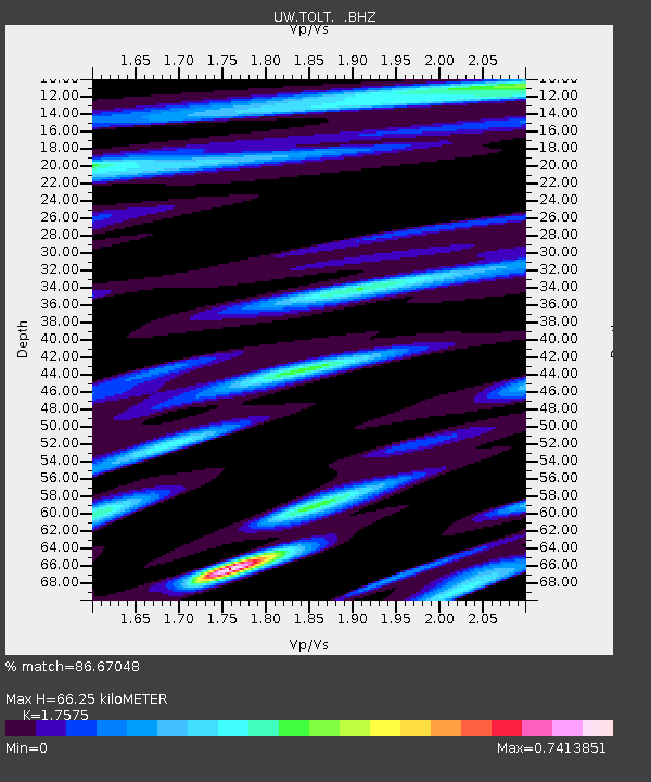
| Estimated Moho Depth: |
66.25 km |
| Estimated Crust Vp/Vs: |
1.76 |
| Assumed Crust Vp: |
6.597 km/s |
| Estimated Crust Vs: |
3.754 km/s |
| Estimated Crust Poisson's Ratio: |
0.26 |
|
| Radial Match: |
86.67048 % |
| Radial Bump: |
400 |
| Transverse Match: |
71.02611 % |
| Transverse Bump: |
400 |
| SOD ConfigId: |
319893 |
| Insert Time: |
2011-01-05 09:46:51.041 +0000 |
| GWidth: |
2.5 |
| Max Bumps: |
400 |
| Tol: |
0.001 |
|

Signal To Noise
| Channel | StoN | STA | LTA |
| UW:TOLT: :BHZ:20100722T05:16:17.035984Z | 21.662642 | 1.6330654E-6 | 7.5386254E-8 |
| UW:TOLT: :BHN:20100722T05:16:17.035984Z | 2.398117 | 2.3553268E-7 | 9.821567E-8 |
| UW:TOLT: :BHE:20100722T05:16:17.035984Z | 4.4822435 | 3.898811E-7 | 8.698347E-8 |
| Arrivals |
| Ps | 7.8 SECOND |
| PpPs | 27 SECOND |
| PsPs/PpSs | 35 SECOND |


