You are here: Home > Network List > QZ - Seismic network of the Seismological Experience and Methodology Expedition CS ME Stations List
> Station INDER Inderbor Kazakhstan (SNECCA) > Earthquake Result Viewer
INDER Inderbor Kazakhstan (SNECCA) - Earthquake Result Viewer
| Earthquake location: |
Southeast Of Honshu, Japan |
| Earthquake latitude/longitude: |
30.0/139.9 |
| Earthquake time(UTC): |
2023/10/05 (278) 01:59:58 GMT |
| Earthquake Depth: |
10 km |
| Earthquake Magnitude: |
6.1 mww |
| Earthquake Catalog/Contributor: |
NEIC PDE/us |
|
| Network: |
QZ Seismic network of the Seismological Experience and Methodology Expedition CS ME |
| Station: |
INDER Inderbor Kazakhstan (SNECCA) |
| Lat/Lon: |
48.50 N/51.69 E |
| Elevation: |
-19.0 m |
|
| Distance: |
67.1 deg |
| Az: |
313.821 deg |
| Baz: |
70.293 deg |
| Ray Param: |
0.057156663 |
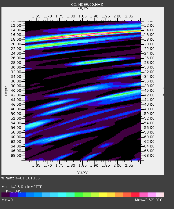
| Estimated Moho Depth: |
16.0 km |
| Estimated Crust Vp/Vs: |
1.85 |
| Assumed Crust Vp: |
5.79 km/s |
| Estimated Crust Vs: |
3.138 km/s |
| Estimated Crust Poisson's Ratio: |
0.29 |
|
| Radial Match: |
81.161835 % |
| Radial Bump: |
400 |
| Transverse Match: |
80.953186 % |
| Transverse Bump: |
400 |
| SOD ConfigId: |
31937991 |
| Insert Time: |
2023-10-19 02:26:59.795 +0000 |
| GWidth: |
2.5 |
| Max Bumps: |
400 |
| Tol: |
0.001 |
|

Signal To Noise
| Channel | StoN | STA | LTA |
| QZ:INDER:00:HHZ:20231005T02:10:21.50003Z | 5.7625513 | 9.77243E-7 | 1.6958512E-7 |
| QZ:INDER:00:HHN:20231005T02:10:21.50003Z | 2.203806 | 3.7771633E-7 | 1.7139273E-7 |
| QZ:INDER:00:HHE:20231005T02:10:21.50003Z | 2.6527126 | 4.8494485E-7 | 1.8281094E-7 |
| Arrivals |
| Ps | 2.4 SECOND |
| PpPs | 7.6 SECOND |
| PsPs/PpSs | 10 SECOND |


