You are here: Home > Network List > AK - Alaska Regional Network Stations List
> Station BPAW Bear Paw Mountain Broadband > Earthquake Result Viewer
BPAW Bear Paw Mountain Broadband - Earthquake Result Viewer
| Earthquake location: |
Mindanao, Philippines |
| Earthquake latitude/longitude: |
6.7/123.4 |
| Earthquake time(UTC): |
2010/07/23 (204) 22:08:11 GMT |
| Earthquake Depth: |
607 km |
| Earthquake Magnitude: |
6.3 MB, 7.3 MW, 7.3 MW |
| Earthquake Catalog/Contributor: |
WHDF/NEIC |
|
| Network: |
AK Alaska Regional Network |
| Station: |
BPAW Bear Paw Mountain Broadband |
| Lat/Lon: |
64.10 N/150.98 W |
| Elevation: |
619 m |
|
| Distance: |
82.1 deg |
| Az: |
26.238 deg |
| Baz: |
268.998 deg |
| Ray Param: |
0.045296304 |
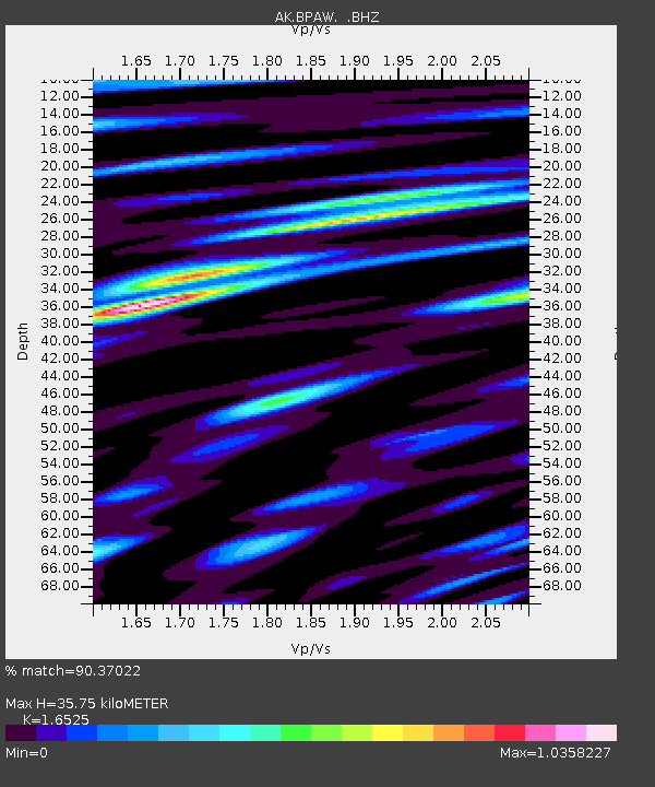
| Estimated Moho Depth: |
35.75 km |
| Estimated Crust Vp/Vs: |
1.65 |
| Assumed Crust Vp: |
6.566 km/s |
| Estimated Crust Vs: |
3.973 km/s |
| Estimated Crust Poisson's Ratio: |
0.21 |
|
| Radial Match: |
90.37022 % |
| Radial Bump: |
400 |
| Transverse Match: |
87.67217 % |
| Transverse Bump: |
400 |
| SOD ConfigId: |
319893 |
| Insert Time: |
2011-01-05 09:52:23.510 +0000 |
| GWidth: |
2.5 |
| Max Bumps: |
400 |
| Tol: |
0.001 |
|

Signal To Noise
| Channel | StoN | STA | LTA |
| AK:BPAW: :BHZ:20100723T22:18:58.208008Z | 62.861286 | 4.859937E-6 | 7.731208E-8 |
| AK:BPAW: :BHN:20100723T22:18:58.208008Z | 4.397768 | 5.1016934E-7 | 1.16006426E-7 |
| AK:BPAW: :BHE:20100723T22:18:58.208008Z | 13.817371 | 1.1588731E-6 | 8.387074E-8 |
| Arrivals |
| Ps | 3.7 SECOND |
| PpPs | 14 SECOND |
| PsPs/PpSs | 18 SECOND |


