You are here: Home > Network List > UU - University of Utah Regional Network Stations List
> Station TCU Toone Canyon, UT, USA > Earthquake Result Viewer
TCU Toone Canyon, UT, USA - Earthquake Result Viewer
| Earthquake location: |
Southeast Of Honshu, Japan |
| Earthquake latitude/longitude: |
30.0/139.9 |
| Earthquake time(UTC): |
2023/10/05 (278) 01:59:58 GMT |
| Earthquake Depth: |
10 km |
| Earthquake Magnitude: |
6.1 mww |
| Earthquake Catalog/Contributor: |
NEIC PDE/us |
|
| Network: |
UU University of Utah Regional Network |
| Station: |
TCU Toone Canyon, UT, USA |
| Lat/Lon: |
41.12 N/111.41 W |
| Elevation: |
2269 m |
|
| Distance: |
83.3 deg |
| Az: |
46.117 deg |
| Baz: |
304.12 deg |
| Ray Param: |
0.04625727 |
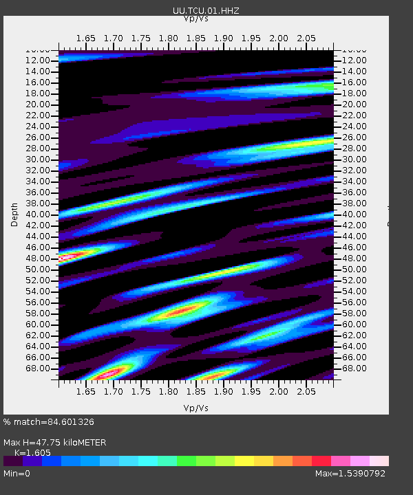
| Estimated Moho Depth: |
47.75 km |
| Estimated Crust Vp/Vs: |
1.61 |
| Assumed Crust Vp: |
6.155 km/s |
| Estimated Crust Vs: |
3.835 km/s |
| Estimated Crust Poisson's Ratio: |
0.18 |
|
| Radial Match: |
84.601326 % |
| Radial Bump: |
400 |
| Transverse Match: |
73.19641 % |
| Transverse Bump: |
400 |
| SOD ConfigId: |
31937991 |
| Insert Time: |
2023-10-19 02:32:58.531 +0000 |
| GWidth: |
2.5 |
| Max Bumps: |
400 |
| Tol: |
0.001 |
|

Signal To Noise
| Channel | StoN | STA | LTA |
| UU:TCU:01:HHZ:20231005T02:11:54.560028Z | 3.3160725 | 6.315416E-7 | 1.9044866E-7 |
| UU:TCU:01:HHN:20231005T02:11:54.560028Z | 1.1321762 | 1.4110358E-7 | 1.2463042E-7 |
| UU:TCU:01:HHE:20231005T02:11:54.560028Z | 1.071364 | 1.7946287E-7 | 1.6750877E-7 |
| Arrivals |
| Ps | 4.8 SECOND |
| PpPs | 20 SECOND |
| PsPs/PpSs | 25 SECOND |


